Groundwater Hydrology
Introduction
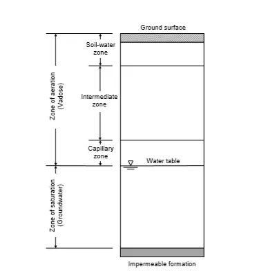
The vertical distribution of water under the ground surface varies in the degree of saturation according to void spaces (Figure 3.1). A region where the void spaces are completely filled with water is called zone of saturation, and that where the void spaces are partly filled with water is the zone of aeration. The former zone is basically the groundwater1, which
occurs due to infiltration of precipitation, streams, lakes, and artificial recharge. Groundwater hydrology is a term referring to the science dealing with groundwater occurrence, properties, and movement. When surface water is not readily available, groundwater becomes a significant source of supply for municipalities, agriculture, and industry.
The unsaturated zone of aeration, also called vadose1, can further be classified into three zones: soil-water, intermediate, and capillary. The soil-water zone, where water from precipitation and irrigation is held by surface tension forces, has agricultural importance as it supplies moisture to plant roots. The intermediate zone varies according to the depth of water table starting from zero when water table approaches the ground surface. The capillary zone extends from the water table up to the limit of which water may rise by capillary effect. This zone may extend only a few centimeters for coarse earth formation to several meters for fine silt. It is not surprising that the zone of saturation has been extensively studied in the literature, while the flow behaviour in the unsaturated zone is not fully investigated as this layer lacks water during normal rainfall events and thus hydrologists are not interested in it.
However, if the unsaturated zone has a shallow depth, then the water level may rise during extreme rainfall events and approach the ground surface. This may affect the entire life at this location including agricultural, commercial and residential activities, and the flooding may last for a long period of time before the water drains. The main questions to answer are, how long the flood will remain in this zone before it drains (days, weeks, months, etc) and how will the water drain (leaking down or disperse).
As a matter of fact, modeling this zone has recently been regarded as an important issue not to prevent flooding, but to provide more factual information to the public through early warning systems and to the insurance companies to become able to price the location of the structure based on how close it is from the flooding area. That is, if the location of the structure is within the flooding area, then the insurance coverage rate would be higher. The material presented here though attempts to emphasize on the classical concepts that govern the flow and storage of the saturated rather than the unsaturated zone.