Hydrograph
Analysis Hydrograph, which is a graph showing changes in water discharge over a period of time for a given point on a channel or conduit, is commonly used in many engineering applications. For example, hydrologists depend on hydrographs to provide peak flow rates so that hydraulic structures can be designed to accommodate the flow safely. Also, the area under the curve of a hydrograph can provide the volume of water, which allows analysis of reservoir sizes, storage tanks, detention ponds, and other facilities that deal with volumes of runoff passing the point of interest during a time period. The shape of the hydrograph changes according to the properties of the basin and meteorological conditions such as rainfall pattern, hydrologic losses, groundwater flow, and surface characteristics including size, roughness, shape, slope and imperviousness. A specific hydrograph can be estimated by following two main steps. Initially, continuous records of water flow versus depth are taken at the channel location. In small channels, these records are estimated by using a device such as a weir. In large channels, placing a flow measuring device in the channel becomes practically difficult, and instead flow rates are measured by using a current meter. Then, a rating curve is plotted, which is a relation between flow rate and stage1.Indirect methods to estimate the water discharge for a given depth is accomplished by employing open channel flow equations such as that of Manning or Chezy. Next, the relation between flow rate and depth is used to transform continuous records of stage versus time into a hydrograph.
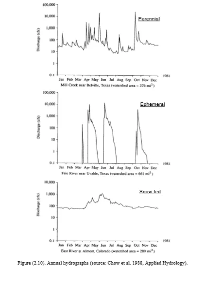
Hydrographs can be classified into annual and storm hydrographs. Annual hydrograph shows the long term water balance in a watershed with a relation between discharge and time over the year, while a storm hydrograph shows the effects of a particular rainfall event on the discharge of a channel. The total volume of flow under the annual hydrograph is the basin yield. Annual hydrographs may be perennial, ephemeral, or snow-fed (Figure 2.10). Perennials have continuous flow over the year which is typical of a humid climate, and most of the basin yield comes from the subsurface flow indicating that a large proportion of rainfall is infiltrated into the basin and reaches the channel as groundwater. Ephemerals are typically found in arid climates with long periods when the channel is dry indicating that the groundwater table is considerably below the channel bed. Basin yield from this watershed is the result of runoff from large storms. Snowfed annual hydrograph has a basin yield occurring mainly in spring and early summer from snowmelt. The large volume of water stored as snow and its steady release develop smoother flow variations over the year than for the perennial or ephemeral.

A common practice is to consider the hydrograph divided into two parts of baseflow and direct surface runoff hydrograph. Baseflow indicates the groundwater contribution, and direct runoff indicates the runoff caused by excess rainfall. The simplest method for the separation of baseflow and direct runoff is by drawing a straight line from B to D. The portion of the hydrograph below BD is considered to be baseflow, and that above BD is the direct runoff.