Abstractions
Water surface runoff at the outlet of a basin is estimated by subtracting the water losses including interception, depression storage, and infiltration that are commonly referred to as abstractions from the rainfall input. Interception is the process by which rainfall is abstracted before reaching the ground. Dense vegetation such as wooded areas1 and roofs of buildings that are not hydraulically connected by pipes to the ground surface are the primary forms of interception. This water is transferred to the atmosphere by evaporation. Depression storage is water accumulating in ground depressions during a storm event that does not contribute to surface runoff. This water is infiltrated into the ground and the remainder is transferred to the atmosphere by evaporation and transpiration processes. Infiltration is the dominant abstraction process by which water seeps into the ground through the soil surface.
Evapotranspiration
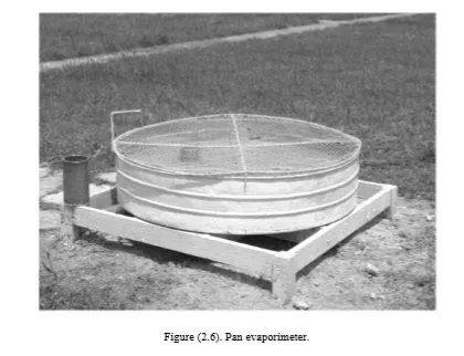
Knowledge of water losses due to evaporation and transpiration is important to account for abstraction processes such as interception and depression storage. Evaporation is the transfer of water from liquid to vapor, while transpiration is the process by which plants remove moisture from the soil and release it to the air as vapor. Evaporation and transpiration processes can be considered together as evapotranspiration. The rate of evapotranspiration is difficult to quantify, since it can vary considerably from one area to another. An approach to estimate the evapotranspiration over an area is attained by using an evapotranspirometer, which is a container of soil and vegetation from which the water loss is measured by weighting all water inflow from the surface and outflow from the bottom of the container. However, as it is also more convenient for desert regions, the estimation is simplified sometimes by considering losses due to evaporation only. A typical measuring instrument of evaporimeter is shown in Figure (2.6), which is based on filling a circular pan with water and determining the decrease in water levels after a specific period of time.
Infiltration
Infiltration is the process by which water seeps into the ground through the earth surface. The spatial variation of infiltration rate over an area is influenced by many factors including the properties of soil and vegetation cover. Water surface runoff occurs only if the rainfall rate for a given time is higher than the infiltration rate. The infiltration rate for a specific location can be measured by a double ring infiltrometer (Figure 2.7). This instrument consists of two rings driven partly into the ground and filled with water. The double ring design helps preventing divergent flow in layered soils. The outer ring acts as a barrier to encourage only vertical flow from the inner ring. The water level in the inner and outer rings should always be maintained at a constant level. The variation of water level in the inner ring, i.e. amount of water added to keep the water level
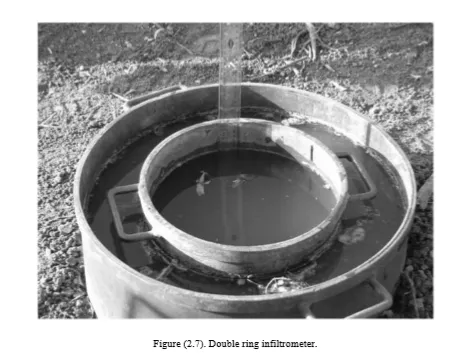
constant in the inner ring is recorded with respect to time. This can be used to determine the volume of water infiltrated per unit area for a given time and produce the infiltration chart for this location. To analyse the infiltration process, the unsteady water flow through the earth may be correlated with the condition of wetting front, which is the interface under the ground between the wet and dry soil. Several empirical models describing the infiltration rate of water through soil are available, each with underlying assumptions and limitations.