Two-Part Blog Series: Flood Assessment, Mitigation & Management
In this two part blog series, we showcase our work in the Moodna Creek Watershed in order to explore some of the concepts and methods used to estimate flood risk for existing conditions and the year 2050 and develop a flood management strategy (Part One), and traditional engineering and natural systems solutions used to manage and reduce flood risk (Part Two).
PART ONE: FLOOD ASSESSMENT & MITIGATION ANALYSIS IN THE MOODNA CREEK WATERSHED
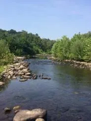
The greater Moodna Creek watershed covers 180 square miles of eastern Orange County, NY. The watershed includes 22 municipalities and hundreds of streams before joining the Hudson River. This region has seen tremendous growth in recent years with the expansion of regional transit networks and critical infrastructure.
 The Moodna Creek
watershed can be split into two sub-basins — the Upper Moodna Creek
and the Lower Moodna Creek. In the span of 15 months, Hurricane Irene, Tropical
Storm Lee, and Hurricane Sandy each have caused significant
flooding throughout the Moodna Creek watershed, damaging public facilities,
roadways, and private properties. Both sub-basin communities have noted a
concern about increased flood risk as more development occurs.
The Moodna Creek
watershed can be split into two sub-basins — the Upper Moodna Creek
and the Lower Moodna Creek. In the span of 15 months, Hurricane Irene, Tropical
Storm Lee, and Hurricane Sandy each have caused significant
flooding throughout the Moodna Creek watershed, damaging public facilities,
roadways, and private properties. Both sub-basin communities have noted a
concern about increased flood risk as more development occurs.
As global temperatures rise, climate models are predicting more intense rainfall events. And, the flood risk for communities along waterways — like the Moodna Creek watershed — will likely increase as time passes. In order to understand existing and future risk from flood events in this flood-prone area, a flood risk management strategy needed to be developed. The strategy uses a cost-benefit analysis to review the feasibility of each measure and the overall impact in reducing flood risks.
With funds provided from a 2016 grant program sponsored by the New England Interstate Waters Pollution Control Commission (NEIWPCC) and the New York State Department of Environmental Conservation’s (NYCDEC) Hudson River Estuary Program (HEP), Princeton Hydro along with a variety of project partners completed a flood assessment and flood mitigation analysis specific to the Lower Moodna Creek watershed.

Let’s take a closer look at our work with the Lower Moodna Creek watershed, and explore some of the methods used to estimate flood risk and develop a flood management strategy:
LOWER MOODNA CREEK WATERSHED FLOOD ASSESSMENT & ANALYSIS
The primary Lower Moodna Creek project goals were to assess flood vulnerabilities and propose flood mitigation solutions that consider both traditional engineering strategies and natural systems solution approaches (land preservation, wetland/forest restoration, green infrastructure and green water management). The project team focused on ways to use the natural environment to reduce risk. Instead of strictly focusing on just Moonda Creek, the team took a holistic approach which included all areas that drain into the river too. These analyses were incorporated into a Flood Assessment Master Plan and Flood Mitigation Plan, which will serve as a road map to reducing flooding issues within the watershed.
MANAGING FLOOD RISK
The first step in managing flood risk is to understand what type of exposure the communities face. The Moodna Creek project modeled flooding within the watershed during normal rain events, extreme rain events, and future rain events with two primary goals in mind:

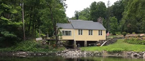
Visual assessment being conducted in flood-prone areas of Moodna Creek Watershed.
· Assess the facilities, infrastructure, and urban development that are at risk from flooding along the Moodna Creek and its tributaries within the study area.
· Develop a series of hydrologic and hydraulic models to assess the extent of potential flooding from the 10-year (10%), 100-year (1%), and 500-year (0.2%) storm recurrence intervals within the study area. The modeling includes flows for these storm events under existing conditions and also hypothetical scenarios with predicted increases in precipitation and population growth.
The project team used these models and data to propose and evaluate a series of design measures that help reduce and mitigate existing and anticipated flood risk within the study area. Where possible, the proposed solutions prioritized approaches that protect and/or mirror natural flood protection mechanisms within the watershed such as floodplain re-connection and wetland establishment. In addition to flood protection, the project components also provide water quality protection, aesthetics and recreation, pollutant reduction, and wildlife habitat creation.
LAND USE AND ZONING
Zoning is a powerful tool that determines a region’s exposure to hazards and risk. Zoning determines which uses are permitted, or encouraged, to be built in moderate and high-risk areas. It also prevents certain uses, such as critical facilities, from being built in those areas. Zoning is also a determinant of a region’s character and identity.
In the Lower Moodna Creek watershed, a large majority (82%) of land is zoned for residential use. However, in the flood-prone areas, there is a higher ratio of areas zoned for non-residential uses (commercial, industrial) than in areas that are zoned for potential future development. Specifically, within the 10-year storm recurrence floodplain, 30% of the land is zoned for industrial use. This is likely because several facilities, such as wastewater treatment plants and mills, require access to the river and were strategically developed to be within immediate proximity of waterfront access. The Lower Moodna zoning analysis demonstrated a general preference within watershed to limit residential use of flood-prone areas.
LAND PRESERVATION
 Preserving land allows for
natural stormwater management, as well as limits the exposure
of development, and minimizes sources of erosion within
the watershed. Preserved land also maintains the hydrologic and ecologic
function of the land by allowing rainwater to be absorbed or retained where
it falls and thus minimizing run-off. If the land within the
floodplain is preserved, it will never be developed, and therefore the
risk — a calculation of rate exposure and the value of the potential
damage — is eliminated. Therefore, land preservation, both within
the floodplains and in upland areas, is the best way to minimize flood damage.
Preserving land allows for
natural stormwater management, as well as limits the exposure
of development, and minimizes sources of erosion within
the watershed. Preserved land also maintains the hydrologic and ecologic
function of the land by allowing rainwater to be absorbed or retained where
it falls and thus minimizing run-off. If the land within the
floodplain is preserved, it will never be developed, and therefore the
risk — a calculation of rate exposure and the value of the potential
damage — is eliminated. Therefore, land preservation, both within
the floodplains and in upland areas, is the best way to minimize flood damage.
Conserved riparian areas also generate a range of ecosystem services, in addition to the hazard mitigation benefits they provide. Protected forests, grasslands, and wetlands along rivers and streams can improve water quality, provide habitat to many species, and offer a wide range of recreational opportunities. Given the co-benefits that protected lands provide, there is growing interest in floodplain conservation as a flood damage reduction strategy.
Within the mapped Lower Moodna floodplains, our assessment determined that there appears to be a slight priority for preserving land most at-risk for flooding. This is likely a consequence of prioritizing land that is closest to riparian areas and preserving wetland areas, which are the most likely to experience flooding. Within the floodplains for the 10-year storm, approximately 22.7% is preserved. For the 100-year storm, approximately 21.2% of the land is preserved. Within the 500-year storm, this number drops slightly to 20.3%. These numbers are so close in part because the difference between the 10-year, 100-year, and 500-year floodplains are small in many areas of the watershed.
HYDROLOGY AND HYDRAULICS
Hydrology is the scientific study of the waters of the earth, with a particular focus on how rainfall and evaporation affect the flow of water in streams and storm drains. Hydraulics is the engineering analysis of the flow of water in channels, pipelines, and other hydraulic structures. Hydrology and hydraulics analyses are a key part of flood management.
 As part of this flood
assessment, Princeton Hydro created a series of hydrologic and
hydraulic (H&H) models to assess the extent of potential flooding
from the 10-year, 100-year, and 500-year storm recurrence intervals within the
Lower Moodna. The modeling, which included flows for these storm events under
existing conditions and future conditions based on predicted increases in
precipitation and population growth, makes it easier to assess what new areas
are most impacted in the future.
As part of this flood
assessment, Princeton Hydro created a series of hydrologic and
hydraulic (H&H) models to assess the extent of potential flooding
from the 10-year, 100-year, and 500-year storm recurrence intervals within the
Lower Moodna. The modeling, which included flows for these storm events under
existing conditions and future conditions based on predicted increases in
precipitation and population growth, makes it easier to assess what new areas
are most impacted in the future.
These are just a few of the assessments we conducted to analyze the ways in which flooding within the watershed may be affected by changes in land use, precipitation, and mitigation efforts. The flood models we developed informed our recommendations and proposed flood mitigation solutions for reducing and mitigating existing and anticipated flood risk.