Groundwater Drawn Downward After Kumamoto Quake
A unique set of high-frequency groundwater level monitoring reveals a loss of approximately ten million cubic meters of groundwater after a major earthquake.
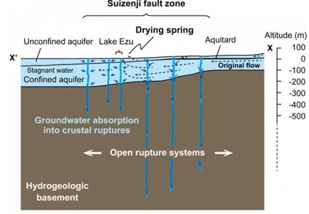
There are many mechanisms that can explain a sudden water level drop after an
earthquake. The unique dataset in this paper shows that the most likely cause
of water disappearing is that it flows into crustal ruptures that are newly
formed during the earthquake.
Major earthquakes are known to affect surface water and groundwater systems; for instance, by altering spring locations, making streams disappear, or causing groundwater levels to drop temporarily or permanently. The study by Hosono et al. [2019] is unique because it provides a rare set of high frequency observations of groundwater and surface water levels before, during, and after a large earthquake.
These data reveal that a large volume of water has disappeared through crustal ruptures formed during the quake, as shown in the diagram above. Not only does this reduce water availability in the region for a whole year but it also causes surface water and shallow groundwater to mix with deeper groundwater with possible long-term negative consequences for groundwater quality.