Chaining in surveying
Definition
Chain survey is the simplest method of surveying. In this survey only measurements are taken in the field, and the rest work, such as plotting calculation etc. are done in the office. This is most suitable adapted to small plane areas with very few details. If carefully done, it gives quite accurate results. The necessary requirements for field work are chain, tape, ranging rod, arrows and sometime cross staff.
![]() It is a system of surveying in which sides of various triangles are measured directly in the field and NO angular measurements are taken.
It is a system of surveying in which sides of various triangles are measured directly in the field and NO angular measurements are taken.
![]() It is the simplest kind of Surveying
It is the simplest kind of Surveying
![]() It is adopted when Level of accuracy required is not high.
It is adopted when Level of accuracy required is not high.
Chain survey steps:
1. Reconnaissance
The preliminary inspection of the area to be chain surveyed is called reconnaissance. The surveyor inspects the area to be surveyed, survey or prepares index sketch or key plan. Walk the whole area and thoroughly examine the ground, note the position of boundaries, road, and river etc., various difficulties to chain lines, select stations, and prepare neat sketches called index sketches or key plan.
2. Marking stations
Stations are marked with ranging rod, or wooden peg, driving a nail or spikes if hard surface, or embedding stone with a cross mark.
3. Reference sketches
After marking the station should be referenced i.e. located by measurement called ties taken from 3 permanent points which are easily identified such as corner of building.
4. Running survey line
After the preliminary work, chaining is started from base line and carried throughout all the line of the framework continuously. So chain is laid and kept lying, offset are taken to locate the nearby details. Make ranging wherever necessary. Measure the change and offset and enter in the field book.
Chain Survey is Suitable when:
![]() Ground is fairly level and simple
Ground is fairly level and simple
![]() Plans are required on large scale e.g. fields
Plans are required on large scale e.g. fields
![]() When area is small in extent
When area is small in extent
Chain Surveying is Not Suitable
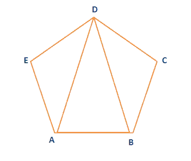
Since the triangle is a simple plane geometrical figure, it can be plotted from the measured length of its sides alone; therefore, the principle of chain survey is Triangulation. In chain surveying, a Network Triangle is preferred. Preferably all the sides of a triangle should be nearly equal having each angle nearly 60 to ensure minimum distortion due to errors in measurement of sides and plotting. Generally such an ideal condition is not practical always. Usually attempt should be made to have WELL CONDITIONED TRIANGLES in which no angle is smaller than 30 and no angle is greater than 120.
Procedure: