LATITUDES AND DEPARTURES
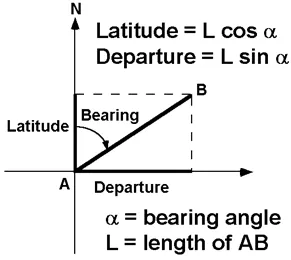
The latitude of a line is its projection on the north-south meridian and is equal to the length of the line times the cosine of its bearing.

CLOSURE OF LATITUDES AND DEPARTURES
DEGREE and RADIAN MEASURE
Trigonometric functions require input data to be stored in radian measure, but the field measurements are in degrees. Therefore a conversion is necessary. Remember that there are 2*pi radians in a circle.
CALCULATION OF LATITUDES AND DEPARTURES (Using azimuths)
Station | Azimuth | Length | Latitude | Departure |
A |
|
|
|
|
| 26° 10' | 285.10 | +255.88 | +125.72 |
B |
|
|
|
|
| 104° 35' | 610.45 | -153.70 | +590.78 |
C |
|
|
|
|
| 195° 30' | 720.48 | -694.28 | -192.54 |
D |
|
|
|
|
| 358° 18' | 203.00 | +202.91 | -6.02 |
E |
|
|
|
|
| 306° 54' | 647.02 | +388.48 | -517.41 |
A |
|
|
|
|
MISCLOSURE | -0.71 | +0.53 | ||
For example, look at the calculation of latitude for the angle from station A to station B:
With a calculator:
26° 10' = 26.16667°
26.16667° * pi/180 = 0.4566945 rad
cos(0.4566945 rad) = 0.897515
0.897515 + 285.10 ft = 255.88 ft
Or in one operation using R:
cos((26 + 10/60) * pi/180) * 285.1
[1] 255.8815
likewise for departure
sin((26 + 10/60) * pi/180) * 285.1
[1] 125.7245
or in Excel:
SIN((26 + 10/60) * PI()/180) * 285.1 = 125.7245
As you can see, setting this up in Excel is fairly straightforward. You will have a record of your measurements and any transformations of those measurements, and it will allow you to check your work easily.

ADJUSTMENT OF LATITUDES AND DEPARTURES
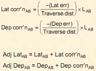
In order to calculate corrections for latitude and departure there is a simple formula called the Compass (or Bowditch) Rule, which is used when angles and distances are measured with the same relative accuracy. There are other methods for different measurement accuracy differentials as well, but this method is simple to implement and works well enough for our purposes.

Station | Azimuth | Length | Latitude | Departure |
A |
| +0.08 | -0.06 | |
| 26° 10' | 285.10 | +255.88 | +125.72 |
B |
| +0.18 | -0.13 | |
| 104° 35' | 610.45 | -153.70 | +590.78 |
C |
| +0.21 | -0.15 | |
| 195° 30' | 720.48 | -694.28 | -192.54 |
D |
| +0.06 | -0.05 | |
| 358° 18' | 203.00 | +202.91 | -6.02 |
E |
| +0.18 | -0.14 | |
| 306° 54' | 647.02 | +388.48 | -517.41 |
A |
|
|
| |
TOTALS | 2466.05 | -0.71 | +0.53 | |
For example, look at line AB.
correction in latitude = -total latitude misclosure / traverse perimeter * length of AB = -(-0.71 / 2466.05 * 285.1) = 0.08
correction in departure = -total departure misclosure / traverse perimeter * length of AB = -(0.53 / 2466.05 * 285.1) = -0.06
Once you have calculated the correction factors, simply add these to the original latitudes and departures to get balanced latitude and departure values..
| Balanced | Balanced | |||
Station | Latitude | Departure | Latitude | Departure | |
A | +0.08 | -0.06 |
|
| |
| +255.88 | +125.72 | +255.96 | +125.66 | |
B | +0.18 | -0.13 |
|
| |
| -153.70 | +590.78 | -153.52 | +590.65 | |
C | +0.21 | -0.15 |
|
| |
| -694.28 | -192.54 | -694.07 | -192.69 | |
D | +0.06 | -0.05 |
|
| |
| +202.91 | -6.02 | +202.97 | -6.07 | |
E | +0.18 | -0.14 |
|
| |
| +388.48 | -517.41 | +388.66 | -517.55 | |
A |
|
|
|
| |
TOTALS |
| -0.71 | +0.53 | 0.00 | 0.00 |
|
|
|
|
|
|
For example, again look at line AB
original latitude AB + correction = 255.85 + 0.08 = 255.96
original departure AB + correction = 125.72 + (-0.06) = 125.66
Also make sure that your balanced latitudes and departures sum to zero, respectively.