UAV-based LiDAR: the future of surveying
A research team from the University of New South Wales and Linke & Linke Surveys has developed a 3D mapping drone that can survey a large area in minutes, saving time, cost and even lives.
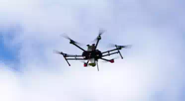
The Unmanned Aerial Vehicle (UAV) weighs approximately 12 kilograms and uses spinning Light Detection and Ranging (LiDAR) to capture 30,000 reference points per second and generate 3D maps in real time.
Director of Linke & Linke Surveys, James Linke said the time and subsequent cost of construction surveys will decrease significantly. “The cost savings would be in the region of 3,000 per cent, compared with a job being done by one person,” said Mr Linke.
“If you have three of four kilometres of stockpiles, it might have taken five to ten days. Now it can be done in 10 minutes, and you have the data ready to use instantaneously,” he said.
Similar UAVs using LiDAR are being developed around the world, increasing the ease and speed of surveying in projects ranging from construction and mapping to mining and natural disaster relief.
Research leader Dr. Johnson Xuesong Shen from UNSW said the technology can go where humans can’t and obtain real time data, assessing work sites and areas hit by natural disasters to determine safety levels.
“We have a research project at the moment looking at the safety of open-pit coal mining,” said Dr Shen. “We can map out the high wall, do some analysis and figure out the risk of collapse.”
While still in prototype phase, UAV LiDAR is set to change the future of surveying, impacting the efficiency, safety and accuracy of surveys across a number of industries around the world.