Vertical control
INTRODUCTION
This chapter describes the various heighting procedures used to obtain the elevation of points of interest above or below a reference datum. The most commonly used reference datum is mean sea level (MSL). There is no such thing as a common global MSL, as it varies from place to place depending on local conditions. It is important therefore that MSL is clearly defined wherever it is used.
The engineer is, in the main, more concerned with the relative height of one point above or below another, in order to ascertain the difference in height of the two points, rather than a direct relationship to MSL. It is not unusual, therefore, on small local schemes, to adopt a purely arbitrary reference datum. This could take the form of a permanent, stable position or mark, allocated such a value that the level of any point on the site would not be negative. For example, if the reference mark was allocated a value of 0.000 m, then a ground point 10 m lower would have a negative value, minus 10.000 m. However, if the reference value was 100.000 m, then the level of the ground point in question would be 90.000 m. As minus signs in front of a number can be misinterpreted, erased or simply forgotten about, they should, wherever possible, be avoided.
The vertical height of a point above or below a reference datum is referred to as the reduced level or simply the level of a point. Reduced levels are used in practically all aspects of construction: to produce ground contours on a plan; to enable the optimum design of road, railway or canal gradients; to facilitate ground modelling for accurate volumetric calculations. Indeed, there is scarcely any aspect of construction that is not dependent on the relative levels of ground points.
Levelling
Levelling is the most widely used method for obtaining the elevations of ground points relative to a reference datum and is usually carried out as a separate procedure from that used for fixing planimetric position.
Levelling involves the measurement of vertical distance relative to a horizontal line of sight. Hence it requires a graduated staff for the vertical measurements and an instrument that will provide a horizontal line of sight.
Definitions
Level line
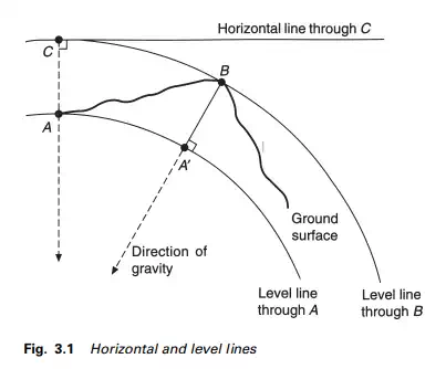
A level line or level surface is one which at all points is normal to the direction of the force of gravity as defined by a freely suspended plumb-bob. As already indicated in Chapter 1 in the discussion of the geoid, such surfaces are ellipsoidal in shape. Thus in Figure 3.1 the difference in level between A and B is the distance A”B, provided that the non-parallelism of level surfaces is ignored.
Horizontal line
A horizontal line or surface is one that is normal to the direction of the force of gravity at a particular point. Figure 3.1 shows a horizontal line through point C.
Datum
A datum is any reference surface to which the elevations of points are referred. The most commonly used datum is that of mean sea level (MSL).
In the UK the MSL datum was measured and established by the Ordnance Survey (OS) of Great Britain, and hence it is often referred to as Ordnance Datum (OD). It is the mean level of the sea at Newlyn in Cornwall calculated from hourly readings of the sea level, taken by an automatic tide gauge over a six-year period from 1 May 1915 to 30 April 1921. The readings are related to the Observatory Bench Mark, which is 4.751 m above the datum. Other countries have different datums; for instance, Australia used 30 tidal observatories, interconnected by 200 000 km of levelling, to produce their national datum, whilst just across the English Channel, France uses a different datum, rendering their levels incompatible with those in the UK.