Elevation angle.
For the case of a geostationary satellite and an earth station having latitude φ and longitude λ relative to the subsatellite point on the equator, the elevation angle (i.e., the angle above the horizon) and the azimuth angle (i.e., the angle measured clockwise from the direction of true North) can be computed by using standard spherical and plane trigonometry relationships. With reference to Fig. 5 and the spherical triangle S′EB at B, we have
Fig. 5. Geometry of elevation and azimuth angles.
(Eq. 23) cosβ=cosφcosλ
Then considering plane triangle OES, we obtain the elevation angle, θ.
(Eq. 24) θ=cos−1{[(R+h)sinβ]/d}
where
d=R2+(R+h)2−2R(R+h)cosβ
The azimuth angle is obtained from the spherical triangle by first using the relationship
(Eq. 25) γ=cos−1(tanφcotβ)
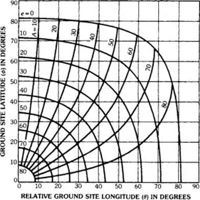
which provides the angle at e; the true azimuth is then obtained from Table 1. The earth-station quadrant is identified with respect to the meridian passing through the subsatellite point and the equator. Fig. 6 provides the look angles to satellites in geostationary orbit.
TABLE 1. TRUE AZIMUTH RELATIONSHIPS
True Azimuth | Earth-Station Quadrant |
180 − γ | NW |
180 + γ | NE |
γ | SW |
360 − γ | SE |