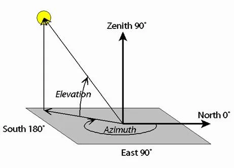
Azimuth angle
Azimuth and Elevation are measures used to identify the position of a satellite flying overhead. Azimuth tells you what direction to face and Elevation tells you how high up in the sky to look. Both are measured in degrees. Azimuth varies from 0° to 360°. It starts with North at 0°. As you turn to your right (in a clockwise direction) you'll face East (which is 90°), then South (which is 180°), then West (which is 270°), and then return to North (which is 360° and also 0°). So if the Azimuth for your satellite is, say, 45°, that means your satellite is northeast of you. Elevation is also measured in degrees. A satellite just barely rising over your horizon would be at 0° Elevation, and a satellite directly overhead would be at 90° Elevation (a.k.a., "the zenith").
In the diagram below, the yellow circle represents the satellite. It has an Azimuth of about 200° (southwest of the observer) and an Elevation of about 60° (about 2/3 of the way up in the sky).
So on the Celestis Satellite Tracking webpage, "START AZIMUTH" tells you what direction the satellite will rise over one horizon in your sky, "MAX ELEVATION" tells you the maximum height the satellite will fly in your sky, and "END AZIMUTH" tells you what direction the satellite will set over another horizon in your sky.
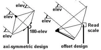
Azimuth refers to the rotation of the whole antenna around a vertical axis. It is the side to side angle. Typically you loosen the main mount bracket and swing the whole dish all the way around in a 360 deg circle.
By definition North is 0 deg, East is 90 deg, South is 180 deg and West is 270 deg. North can also be called 360 deg.
Note that you find a satellite by pre-setting the elevation accurately and then swinging the whole antenna boldly in azimuth till the signal locks up - so an approximate azimuth angle is normally sufficient.
The dish pointing calculator gives the required azimuth angle both relative to true north and relative to magnetic compass north.
When using a magnetic compass keep away from metal structures. This is obviously a problem in many cases both with the antenna steelwork and building structures. If, for example, you have a close angle clearance problem with say an adjacent wall then you may need to walk some distance away and sight towards the satellite from say 50 yards back. Large scale precision maps / plans can be useful in accurately defining angles. Also consider long range views of say church towers that might provide an accurate azimuth reference.
If you are in the northern hemisphere then remember that the sun rises in the east, reaches its highest angle at due south and sets in the west.
If you are in the southern hemisphere then remember that the sun rises in the east, reaches its highest angle at due north and sets in the west.
If you are away from the equator and it is a sunny day you can approximately determine south simply by considering where the sun is and the general time of day. To calculate sun or moon angles at any time go here aa.usno.navy.mil Sun or moon altitude is the same thing as elevation angle.
If you are near the equator note where the sun rose this morning - that is approximately east.
The north pole star gives a good fix if you are in the northern hemisphere and not too close to the equator. Here is how to find true north using the pole star.
Some GPS receivers show a view of the sky with the sun and moon marked. Line up with one of these and you have a good bearings. Also with GPS you can walk a while in a straight line and determine the azimuth bearing angle of that line.
Azimuth and elevation refer to the satellite TV dish pointing angles.
|
|