Argos Platforms
Argos is a unique worldwide location and data collection system dedicated to studying and protecting the environment.
A wide selection of Argos platforms exist and CLS can help choose the transmitter that fits your needs
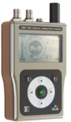
Argos goniometer:
Argos Direction Finder for Recovery & Tracking
The CLS goniometer helps users find active ARGOS platforms in the field.Depending on the altitude and the reception conditions the goniometer can detect all transmitting platforms within a radius of 100 km or more.
Argos transmitters to track animals
Argos transmitters provide an accurate means of monitoring wildlife through all types of habitats and climates. There are a variety of transmitters for land animals, marine animals and birds that are ideally suited for migration and habitat studies. There are diffrent types of products : ideally suited to wildlife behaviour and habitat utilization studies, including fin tag and glue-on attachment for marine applications or reducing one (small than 5 gr) for birds…

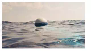
Drifting buoys
Drifting buoys provide operational, near-real time surface velocity, sea surface temperature (SST) and sea level pressure observations for numerical weather forecasting, research, and in-situ calibration/verification of satellite observations. Drifting buoys are generally attached to some form of drogue or sea-anchor, are easy to deploy, are relatively inexpensive to operate and reliably measure the atmosphere and ocean surface conditions, for an average of 18 months.
Ice buoys
Ice buoys can measure a variety of oceanographic and meteorological data which are relayed through the ARGOS satellite system. Ice buoys have been used extensively in Arctic and Antarctic regions to track ice movement and are available commercially for deployment by ships or aircraft. Such buoys are equipped with low temperature electronics and lithium batteries that can operate at temperatures down to -50°C.

Moored buoys
Moored buoys are normally relatively large and expensive platforms. They can vary from a few meters in height and breadth, to over 12 meters. Measurements from the mooring include surface variables : wind, air and sea surface temperature, salinity, air pressure, as well as subsurface temperatures down to a depth of 500 plus meters.

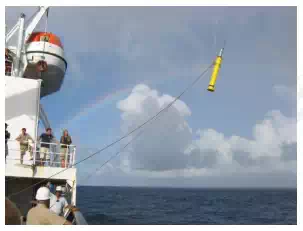
Subsurface floats
Subsurface floats or argos profiling float are gathering data at mid-depth and surfacing from time to time to transmit. These platforms are coordinated under the Argo program led by JCOMMOPS which is an international collaboration that collects high-quality temperature and salinity profiles from the upper 2000m of the ice-free global ocean and currents from intermediate depths.
Any equipment integrating an Argos-certified transmitter is referred to as a ‘platform’. Powered by batteries or solar energy, the Argos transmitters upload short duration messages (of less than one second) to Argos instruments on satellites that pass overhead at an altitude of 850 km.
Each platform is characterized by an identification number specific to its transmitter. A platform transmits periodic messages characterized by the following parameters :
Transmission Frequency (401.650 MHz ± 30 kHz, which must be stable as the location is computed on the basis of Doppler effect measurements, the Repetition period, which is the interval of time between two consecutive message dispatches, varying between 90 and 200 seconds according to the extent to which the platform is used, the platform identification number, and the volume of data collected.
The transmission of each message takes less than one second.
Polar orbiting satellites collecting data:
flying at an orbit of 850 km above the earth pick up the signals and store them on-board and relay them in real-time back to earth.
The satellites are on a polar orbit at an altitude of 850 km
The satellites see the North and South Poles on each orbital revolution. The orbit planes revolve around the polar axis at the same speed as the Earth around the Sun, i.e. one revolution a year. Each orbital revolution transects the equatorial plane at fixed local solar times. Therefore, each satellite passes within visibility of any given transmitter at almost the same local time each day. The time taken to complete a revolution around the Earth is approximately 100 minutes.
At any given time, each satellite simultaneously “sees” all transmitters within an approximate 5000 kilometer diameter “footprint”, or visibility circle. As the satellite proceeds in orbit, the visibility circle sweeps a 5000 kilometer swath around the Earth,covering both poles.
Due to the Earth’s rotation, the swath shifts 25° west (2800 km at the Equator) around the polar axis at each revolution. This results in overlap between successive swaths. Since overlap increases with latitude, the number of daily passes over a transmitter also increases with latitude.
At the poles, the satellites see each transmitter on every pass, approximately 14 times per day per satellite.
The period during which the satellite can receive messages from a platform is equivalent to the time during which the platform is within its visibility. On average this is 10 minutes.
Argos messages are received by the satellite simultaneously. They are stored on the onboard recorder and retransmitted to the ground each time the satellite passes over one of the three main receiving stations based on Wallops Island (Virginia, United States), Fairbanks (Alaska, United States), and Svalbard (Norway), or they are retransmitted to the ground to regional reception stations in the satellites’s field of view.