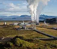
Nesjavellir Geothermal Power Station
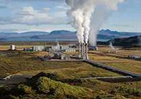
The Nesjavellir Geothermal Power Station is
the second largest geothermal power plant in Iceland. The facility
is located 177 m (581 ft) above sea level in the
southwestern part of the country, near Thingvellir and the Hengill Volcano.
Plans
for utilizing the Nesjavellir area
for geothermal power and water heating began in 1947, when
some boreholes were drilled to evaluate the area's potential for power
generation. Research continued from 1965 to 1986. In 1987, the construction of
the plant began, and the cornerstone was laid in May 1990. The station produces
approximately 120MW of electrical power, and delivers around 1,800 litres (480
US gal) of hot water per second, servicing the hot water needs of the Greater
Reykjavík Area.
|
NESJAVELLIR GEOTHERMAL POWER STATION |
|
|
Nesjavellir Geothermal Power Station |
|
|
LOCATION |
Thingvellir,
|
|
STATUS |
Completed |
|
FUEL |
Geothermal |
|
INSTALLED CAPACITY |
120 MW |
|
COMMISSIONED |
May 1990 |