Structural Geology
structural geology deals with the geometric relationships of rocks and geologic features in general. The scope of structural geology is vast, ranging in size from submicroscopic lattice defects in crystals to mountain belts and plate boundaries.
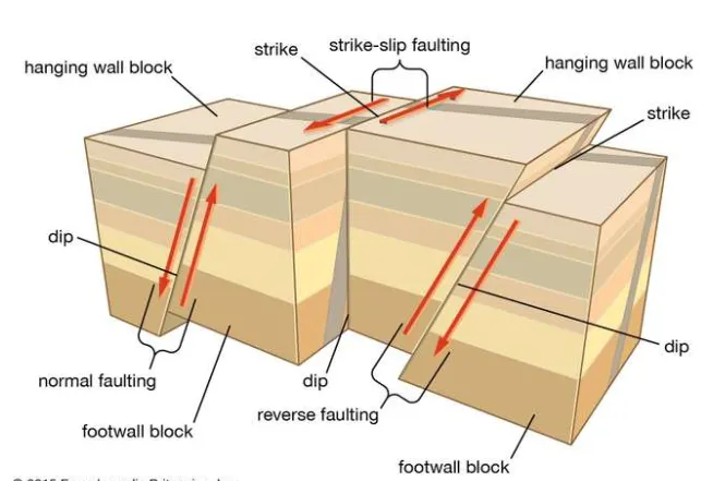
Structures may be divided into two broad classes: the primary structures that were acquired in the genesis of a rock mass and the secondary structures that result from later deformation of the primary structures. Most layered rocks (sedimentary rocks, some lava flows, and pyroclastic deposits) were deposited initially as nearly horizontal layers. Rocks that were initially horizontal may be deformed later by folding and may be displaced along fractures. If displacement has occurred and the rocks on the two sides of the fracture have moved in opposite directions from each other, the fracture is termed a fault; if displacement has not occurred, the fracture is called a joint. It is clear that faults and joints are secondary structures; i.e., their relative age is younger than the rocks that they intersect, but their age may be only slightly younger. Many joints in igneous rocks, for example, were produced by contraction when the rocks cooled. On the other hand, some fractures in rocks, including igneous rocks, are related to weathering processes and expansion associated with removal of overlying load. These will have been produced long after the rocks were formed. The faults and joints referred to above are brittle structures that form as discrete fractures within otherwise undeformed rocks in cool upper levels of the crust. In contrast, ductile structures result from permanent changes throughout a wide body of deformed rock at higher temperatures and pressures in deeper crustal levels. Such structures include folds and cleavage in slate belts, foliation in gneisses, and mineral lineation in metamorphic rocks.
The methods of structural geology are diverse. At the smallest scale, lattice defects and dislocations in crystals can be studied in images enlarged several thousand times with transmission electron microscopes. Many structures can be examined microscopically, using the same general techniques employed in petrology, in which sections of rock mounted on glass slides are ground very thin and are then examined by transmitted light with polarizing microscopes. Of course, some structures can be studied in hand specimens, which were preferably oriented when collected in the field.
On a large scale, the techniques of field geology are employed. These include the preparation of geologic maps that show the areal distribution of geologic units selected for representation on the map. They also include the plotting of the orientation of such structural features as faults, joints, cleavage, small folds, and the attitude of beds with respect to three-dimensional space. A common objective is to interpret the structure at some depth below the surface. It is possible to infer with some degree of accuracy the structure beneath the surface by using information available at the surface. If geologic information from drill holes or mine openings is available, however, the configuration of rocks in the subsurface commonly may be interpreted with much greater assurance as compared with interpretations involving projection to depth based largely on information obtained at the surface. Vertical graphic sections are widely used to show the configuration of rocks beneath the surface. Balancing cross sections is an important technique in thrust belts. The lengths of individual thrust slices are added up and the total restored length is compared with the present length of the section and thus the percentage of shortening across the thrust belt can be calculated. In addition, contour maps that portray the elevation of particular layers with respect to sea level or some other datum are widely used, as are contour maps that represent thickness variations.
Strain analysis is another important technique of structural geology. Strain is change in shape; for example, by measuring the elliptical shape of deformed ooliths or concretions that must originally have been circular, it is possible to make a quantitative analysis of the strain patterns in deformed sediments. Other useful kinds of strain markers are deformed fossils, conglomerate pebbles, and vesicles. A long-term aim of such analysis is to determine the strain variations across entire segments of mountain belts. This information is expected to help geologists understand the mechanisms involved in the formation of such belts.
A combination of structural and geophysical methods are generally used to conduct field studies of the large-scale tectonic features mentioned below. Field work enables the mapping of the structures at the surface, and geophysical methods involving the study of seismic activity, magnetism, and gravity make possible the determination of the subsurface structures.
The processes that affect geologic structures rarely can be observed directly. The nature of the deforming forces and the manner in which the Earth’s materials deform under stress can be studied experimentally and theoretically, however, thus providing insight into the forces of nature. One form of laboratory experimentation involves the deformation of small, cylindrical specimens of rocks under very high pressures. Other experimental methods include the use of scale models of folds and faults consisting of soft, layered materials, in which the objective is to simulate the behaviour of real strata that have undergone deformation on a larger scale over much longer time.
Some experiments measure the main physical variables that control rock deformation—namely, temperature, pressure, deformation rate, and the presence of fluids such as water. These variables are responsible for changing the rheology of rocks from rigid and brittle at or near the Earth’s surface to weak and ductile at great depths. Thus, experimental studies aim to define the conditions under which deformation occurs throughout the Earth’s crust.
Tectonics
The subject of tectonics is concerned with the Earth’s large-scale structural features. It forms a multidisciplinary framework for interrelating many other geologic disciplines, and thus it provides an integrated understanding of large-scale processes that have shaped the development of our planet. These structural features include mid-oceanic rifts; transform faults in the oceans; intracontinental rifts, as in the East African Rift System and on the Tibetan Highlands; wrench faults (e.g., the San Andreas Fault in California) that may extend hundreds of kilometres; sedimentary basins (oil potential); thrusts, such as the Main Central thrust in the Himalayas, that measure more than 2,000 kilometres long; ophiolite complexes; passive continental margins, as around the Atlantic Ocean; active continental margins, as around the Pacific Ocean; trench systems at the mouth of subduction zones; granitic batholiths (e.g., those in Sierra Nevada and Peru) that may be as long as 1,000 kilometres; sutures between collided continental blocks; and complete sections of mountain belts, such as the Andes, the Rockies, the Alps, the Himalayas, the Urals, and the Appalachians-Caledonians. Viewed as a whole, the study of these large-scale features encompasses the geology of plate tectonics and of mountain building at the margins of or within continents.
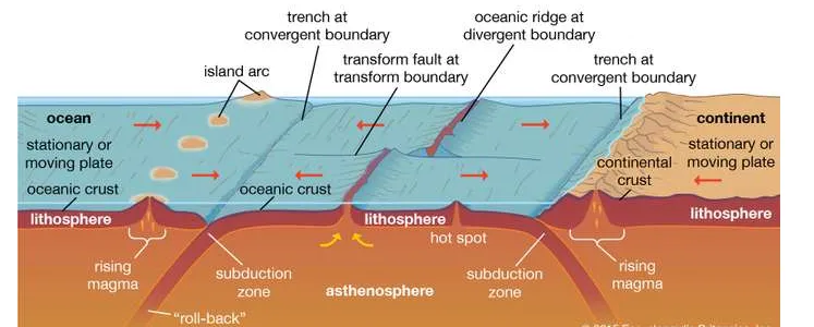
crustal generation and destructionThree-dimensional diagram showing crustal generation and destruction according to the theory of plate tectonics; included are the three kinds of plate boundaries—divergent, convergent (or collision), and strike-slip (or transform).Encyclopædia Britannica, Inc.
Volcanology
Volcanology is the science of volcanoes and deals with their structure, petrology, and origin. It is also concerned with the contribution of volcanoes to the development of the Earth’s crust, with their role as contributors to the atmosphere and hydrosphere and to the balance of chemical elements in the Earth’s crust, and with the relationships of volcanoes to certain forms of metallic ore deposits.
Many of the problems of volcanology are closely related to those of the origin of oceans and continents. Most of the volcanoes of the world are aligned along or close to the major plate boundaries, in particular the mid-oceanic ridges and active continental margins (e.g., the “Ring of Fire” around the Pacific Ocean). A few volcanoes occur within oceanic plates (e.g., along the Hawaiian chain); these are interpreted as the tracks of plumes (ascending jets of partially molten mantle material) that formed when such a plate moved over hot spots fixed in the mantle.
One of the principal reasons for studying volcanoes and volcanic products is that the atmosphere and hydrosphere are believed to be largely derived from volcanic emanations, modified by biological processes. Much of the water present at the Earth’s surface, which has aggregated mostly in the oceans but to a lesser extent in glaciers, streams, lakes, and groundwater, probably has emerged gradually from the Earth’s interior by means of volcanoes, beginning very early in the Earth’s history. The principal components of air—nitrogen and oxygen—probably have been derived through modification of ammonia and carbon dioxide emitted by volcanoes. Emissions of vapours and gases from volcanoes are an aspect of the degassing of the Earth’s interior. Although the degassing processes that affect the Earth were probably much more vigorous when it was newly formed about 4,600,000,000 years ago, it is interesting to consider that the degassing processes are still at work. Their scale, however, is vastly reduced compared with their former intensity.
The study of volcanoes is dependent on a variety of techniques. The petrologic polarizing microscope is used for classifying lava types and for tracing their general mineralogical history. The X-ray fluorescence spectrometer provides a tool for making chemical analyses of rocks that are important for understanding the chemistry of a wide variety of volcanic products (e.g., ashes, pumice, scoriae, and bombs) and of the magmas that give rise to them. Some lavas are enriched or depleted in certain isotopic ratios that can be determined with a mass spectrometer. Analyses of gases from volcanoes and of hot springs in volcanic regions provide information about the late stages of volcanic activity. These late stages are characterized by the emission of volatile materials, including sulfurous gases. Many commercially valuable ore deposits have formed through the influence of hydrothermal volcanic solutions.
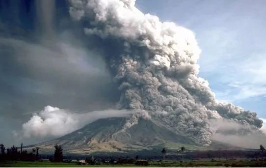
Volcanoes may pose a serious hazard to human life and property, as borne out by the destruction wrought by the eruptions of Mount Vesuvius (79 CE), Krakatoa (1883), Mount Pelée (1902), and Mount Saint Helens (1980), to mention only a few. Because of this, much attention has been devoted to forecasting volcanic outbursts. In 1959 researchers monitored activity leading up to the eruption of Kilauea in Hawaii. Using seismographs, they detected swarms of earthquake tremors for several months prior to the eruption, noting a sharp increase in the number and intensity of small quakes shortly before the outpouring of lava. Tracking such tremors, which are generated by the upward movement of magma from the asthenosphere, has proved to be an effective means of determining the onset of eruptions and is now widely used for prediction purposes. Some volcanoes inflate when rising molten rock fills their magma chambers, and in such cases tiltmeters can be employed to detect a change in angle of the slope before eruption. Other methods of predicting violent volcanic activity involve the use of laser beams to check for changes in slope, temperature monitors, gas detectors, and instruments sensitive to variations in magnetic and gravity fields. Permanent volcano observatories have been established at some of the world’s most active sites (e.g., Kilauea, Mount Etna, and Mount Saint Helens) to ensure early warning.