 ....................(1)
Resistivity and spontaneous (SP) logging
Resistivity logging is an important branch of well logging. Essentially, it is the recording, in uncased (or, recently, even cased) sections of a borehole, of the resistivities (or their reciprocals, the conductivities) of the subsurface formations, generally along with the spontaneous potentials (SPs) generated in the borehole. This recording is of immediate value for geological correlation of the strata and detection and quantitative evaluation of possibly productive horizons. The information derived from the logs may be supplemented by cores (whole core or sidewall samples of the formations taken from the wall of the hole).
Several types of resistivity measuring systems are used that have been designed to obtain the greatest possible information under diverse conditions (see links below). Many service companies offer resistivity-logging services, and most offer a Web-based catalog that describes each service.
Earth resistivity
Formation resistivity is a key parameter in determining hydrocarbon saturation. An electric current can pass through a formation because it contains water with enough dissolved ions to be conductive. With a few rare exceptions, such as metallic sulfides and graphite, dry rock matrix is a good electrical insulator. However, perfectly dry rocks seldom occur below ground level, so nearly all subsurface formations have finite, measurable resistivities because of the water in their pores, adsorbed onto their grain surfaces, or absorbed into a clay structure.
The resistivity of a formation depends on the resistivity of the formation water, the amount of water present, and the structure and geometry of the pores. The resistivity (specific resistance) of a substance is the electrical resistance measured between opposite faces of a unit cube of the substance at a specified temperature or, generally,
where R = resistivity in ohm•m, r = resistance in ohm, A = area in m2 , and L = length in m.
Conductivity, σ, is the reciprocal of resistivity, expressed in Siemens/m. To avoid the excessive use of small decimal numbers in well logging, conductivity is expressed in milliSiemens/m (mS/m), where 1000 mS/m = 1 Siemen/m, so
Formation resistivities are usually in the range of 0.2 to 1000 ohm•m. Resistivities higher than 1000 ohm•m are uncommon in most permeable formations but are observed in impervious, low-porosity formations such as evaporites. A few low-porosity hydrocarbon-bearing formations with almost no formation water can have resistivities as high as 20 000 ohm•m.
Formation resistivities are measured either by passing a known current through the formation and measuring the electrical potential (electrode or galvanic devices) or by inducing a current distribution in the formation and measuring its magnitude (induction devices).
Because resistivities cannot be read accurately over the entire measurement range when displayed on a linear scale, all resistivity logs are now presented on logarithmic grids, usually in 4 decades across two log tracks. This allows the display of readings from 0.2 to 2000 ohm•m, with a single curve covering the useful range of nearly all logs. A backup curve is used in the exceptional cases of readings outside that range. As resistivity data are used more and more digitally, and the log plots are mostly for reference, other formats are in wide use.
Most wireline resistivity-logging tools also have the ability to measure and record small differences in electrical potential that occur spontaneously in conductive muds as a continuous SP curve. The SP curve records the electrical potential differences generated by the interaction of formation water, conductive drilling fluid, and ion-selective shales. It has a wide range of formation-evaluation applications, including:
· Differentiating potentially porous and permeable reservoir rocks from impermeable clays and shales
· Defining bed boundaries
· Correlating nearby wells
· Indicating the shaliness of shaly formations
· Estimating formation-water resistivity, Rw
The logging environment
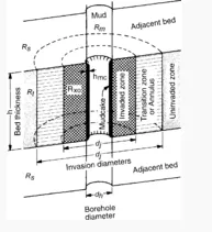
Measuring the resistivity of formations of interest is complicated by the invasion of drilling fluids into permeable rocks. The invaded fluid can displace some or all of the connate water or hydrocarbon present. The resistivity of the borehole is often much less than the formations of interest, sometimes by orders of magnitude. In addition, the formation often consists of rock layers with widely varying resistivity. Fig. 1 shows these factors.

Fig. 1 – The borehole/formation environment for well logging.
To measure the uninvaded portion of the rock from the borehole, a resistivity device must include a large volume of formation—there must be adequate sensitivity to the region of interest. Over the years, the main developments in resistivity-logging tools have been targeted at eliminating response from unwanted parts of the formation and recovering the resistivity of the uninvaded portion of a single layer. The response from unwanted parts of the formation is lumped under the term "environmental effects."
The main objectives of resistivity logs are the determination of Rt and Rxo and, for the newer imaging devices, the mapping of resistivity profiles into and around the borehole. This is accomplished by incorporating devices with at least three, and preferably more, depths of investigation. The deep-reading focused devices include:
· The deep laterolog device (LLd)
· The deep induction (ILd) device
Medium-depth devices include:
· The shallow laterolog (LLs)
· The medium induction (ILm)
The shallow devices include:
· The microresistivity device
· The spherically focused log (SFL)
The latest laterolog and induction tools include arrays focused at many depths of investigation—from five to eight depths—measured simultaneously. These allow a better description of the invaded zone and allow for interpretation of complex invasion profiles.