Magnetic field of the Earth
From the point of view of the magnetic exploration we can divide the Earth’s magentic field onto three componenets:
1. The main field originating within the Earth’s interior and changing relatively slowly.
2. A small field (compared to the main field) which varies relatively rapidly and originates outside of the Earth.
3. Spatial variations of the main field, usually smaller than the main field and usually invariant in the time and place, caused by the inhomogeneities of the Earth’s crust.
These are the target of the magnetic exploration.
The main field
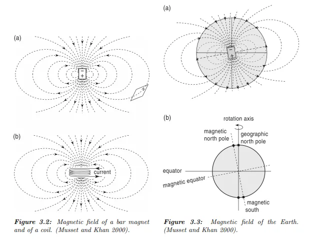
According to the electromagnetic theory the magnetic field is a consequence of a flow of electrically charged particles (electric current). A current flowing in a circular loop acts as a magnetic dipole located in the canter of the loop (Fig. 3.2). The magnetic field of the Earth (the geomagnetic field) is supposed to be formed like this – by the electric currents flowing in the outer core, the geodynamo. The currents are generated by convection currents in the conductive liquid outer core, however, the process is complex and not fully understood so far.
The principle component of the Earth’s magnetic field is the dipole, but also higher orders are present. (These are predominating during the poles reversals, where the main (dipole) field is ceasing.) Hence the geomagnetic field could be approximated by a dipole situated in the Earth’s centre (Fig. 3.3). The dipole is not aligned with the rotation axis and hence the magnetic pole is deviated from the geographic pole. The deviation from the geographic direction is called the magnetic declination (Fig. 3.4). The angle at which the lines of the magnetic field intersects the Earth’s
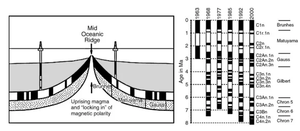
Formation of marine magnetic anomalies during seafloor spreading (left). The oceanic crust is formed at the ridge crest, and while spreading away from the ridge it is covered by an increasing thickness of oceanic sediments. The black (white) blocks of oceanic crust represent the original normal (reversed) polarity thermoremanent magnetization (TRM) acquired upon cooling at the ridge. The black and white blocks in the drill holes represent normal and reversed polarity depositional remanent magnetization (DRM) acquired during deposition of the marine sediments. Development of the geomagnetic polarity time scale (GPTS) through time (right) shows that the initial assumption of periodic behavior (in 1963) was soon abandoned as new data became available.
The first modern GPTS based on marine magnetic anomaly patterns was established in 1968. Subsequent revisions show improved age control and increased resolution (Krijgsman and Landereis 2008). surface is called the magnetic inclination (see Figs. 3.3 and 3.4). The inclination is called positive when the lines point down. Therefore, it ranges from 90◦at the north magnetic pole through the 0 ◦at the magnetic equator down to -90◦at the south magnetic pole. See also Figures 3.5, 3.6 and 3.7. Since the overall geomagnetic field does not reflect any features of surface geology (mountain ranges, mid-ocean ridges, etc.) it implies that the source of the field is located deep within the Earth. Paleomagnetic data show that the magnetic field has always been roughly oriented parallel to the Earth’s rotation axis suggesting that the convective currents are connected to the Earth’s spin. The geomagnetic field slowly changes throughout the time – secular variations of the field. The position of the poles changes as well as its intensity.
The period of these changes is long – e.g. there is a set of eight places with high changes of geomagnetic field (also called foci). These foci moves slowly westwards, it is estimated that they will travel around the globe in about 1800 years. Changes of the position of the poles (and consecutive changes of inclination and declination) are thought to be caused by changes in the convection currents within the Earth’s core. The orientation of the geomagnetic field is more or less stable for a long time (e.g. more than several tens or hundreds thousands of years). However, time to time the orientation swaps – the north pole moves suddenly to the south and vice versa. – reversals of geomagnetic field.
The changes are sudden (in comparison with time of the stable field, the durations of reversals are modelled to last one or several thousands of years). During the reversals, the dipole field ceases and only the higher-pole fields are present, hence the overall geomagnetic field is much smaller and there is no magnetic north and south. The sudden changes of geomagnetic field were documented on samples from boreholes and outcrops all around the globe and were assembled into a magnetostratigraphical chart (Fig. 3.8). The received “barcode” pattern could be used for dating geological samples (Fig. 3.9). First of all, one have to obtain some initial estimate of possible age of the sampled profile. Next, the reversal pattern could be correlated with the chart.