Applications of the gravity method
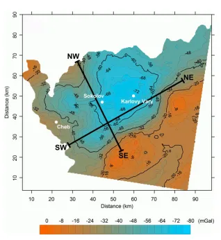
The gravity measurements could, obviously, be applied anywhere where sufficient density contrast is expected. Nevertheless, there are situations and field conditions suitable and unsuitable. Lets start with the former. One of the scenes where gravity excels is a regional geological mapping. It is due to the fact that the gravity meter is easily portable, does not need any wires and cables and one or two people are enough to operate it. Therefore, there is no logistic problem in measuring long (several kilometres or even more) traverses. Another advantage is the high depth reach – it is common to model structures in the depth of several kilometres (Fig. 2.20, 2.21).
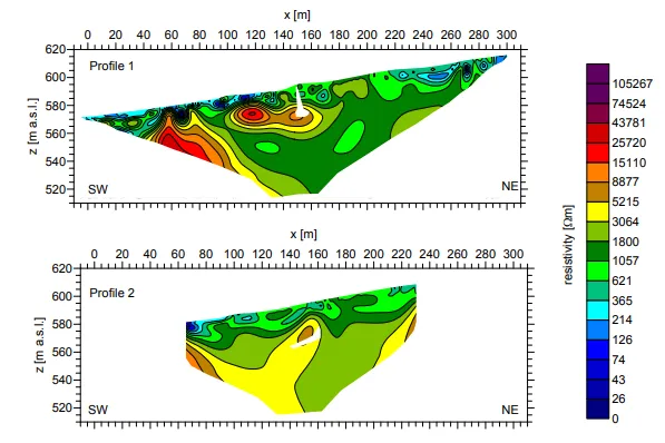
Another field where the gravity measurements are indispensable is the mapping of voids (cavities). There are not many geophysical methods that could directly detect voids (ground penetration radar being the second). Therefore, the gravity method is often used to search caves (Fig. 2.22), old mines and galleries, or different voids and cavities beneath the roads.
Very common application of the gravity method is mapping of the sedimentary basins for the oil prospection. If the densitites of sediments are known (e.g. from boreholes) then not only the lateral extent but also the depth of the basins could be mapped. Another example from the oil prospection is the mapping of salt domes, since they often form oil and gas deposits. This set of examples could be finished by a volcanological example – maar-diatreme volcanoes are often mapped using the gravity data.
The eruption of the maar volcano is very forceful, the explosion creates a large crater and shatters the country rock. After the explosion, part of the material falls back to the crater, however, is "fluffed up" by the explosion and hence its density is lower then used to be. Therefore a gravity profile crossing the diatreme shows a distinct gravity low (Fig. 2.21). However, the best results are always obtained by combination of several geophysical methods. An example combining gravity and resistivity data is plotted in the figure


Resistivity cross-sections along the gravimetric profiles from the figure 2.22. Areas with high resistivities (yellow, brown and red colors) represents blocks of marble where the caves could evolve. White areas represent caves modeled according to the gravity data.
A resistivity cross-section on the Tertiary maar-diatreme volcano from the Fig.2.19. High resistivities (in red) depicts area of volcanoclastic sediments and basaltic dikes. The yellow line highlights the extent of the diatreme on the surface, the blue dashed line depicts an interpreted shape of the diatreme. The interpreted basaltic dikes from are plotted in violet. The depth of the resistivity cross-section is 60 metres, the diameter of the diatreme is 220 metres.