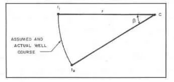
Radius of Curvature
The radius of curvature method is currently considered to be one of the most accurate methods available. The method assumes the wellbore course is a smooth curve between the upper and lower survey stations. The curvature of the arc is determined by the survey inclinations and azimuths at the upper and lower survey stations as shown below. The length of the arc between I; and I2 is the measured depth between surveys. In the previous methods, the wellbore course was assumed to be one or two straight lines between the upper and lower survey points. The curvature of the wellbore course assumed by the radius of curvature method will more closely approximate the actual well; therefore, it is more accurate. Unfortunately, the equations are complicated and are not easily calculated in the field without a programmable calculator or computer.
A closer inspection of the radius of curvature equations show that if the inclination or azimuth are equal for both survey points, a division by zero will result in an error. In this case, the minimum curvature or average angle methods can be used to make the calculations. It is also possible to add a small number (such as 1 x 10⁻⁴) to either survey point. The resulting error will be insignificant.
Generally, the radius of curvature calculations is used when planning a well. Using one of the three previous methods to plan a well will result in substantial errors when calculating over long intervals
ATVD = (180) X (AMD) X (Sin/? +Sin/i) n X (/? - /1)
ANorth = (180)2 X (AMD) X (Cos/i - Cos/?) X (SinA ? - SinA i)l n2 X (/? - /1) X (A? - Ai)
AEast = (180)2 X (AMD) X (Cos/i - Cos/?) X (CosAi - CosA?)l n2 X (/? - /i) X (A? - Ai)