What are various GNSS systems?

Checking out a new coffee house in the town or exploring your dream travel destination like a local is not a big thing now. Wherever you get stuck, you take out your phone type the destination and navigate to the place. But, have you ever wondered how this tiny mobile device in your hand directs you to every nook and corner? Of course you know, it is the tiny GPS chip in the phone which does the magic. GPS provides the location and time information anywhere on the earth.
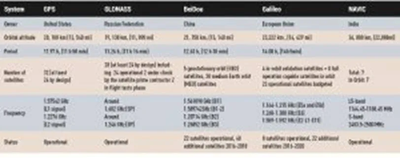
But did you know GPS, or Global Positioning System, is one of the four Global Navigation Satellite Systems? The four global GNSS systems are – GPS (US), GLONASS (Russia), Galileo (EU), BeiDou (China). Additionally, there are two regional systems – QZSS (Japan) and IRNSS or NavIC (India).
Check out our special story on Evolution of the Global Navigation Satellite System
GPS is the oldest GNSS system. It initiated its operations in 1978 and was available for global use from 1994.
The need to have an independent military navigation capability drove its innovation. And, US military was first to realize this. And thus, in 1964 the Transit system was deployed for the purpose. Transit, which was also known as NAVSAT, worked on the Doppler Effect and use to provide location information and navigation to missile submarines, surface ship and also to hydrographic survey and geodetic surveying to the US army. With time, GPS was opened up for public use. Currently, GPS has a 33 satellite constellation, out of which 31 are in orbit and operational. It is maintained by the US Air Force and is committed to maintaining the availability of at least 24 operational GPS satellites. Till date, GPS has launched 72 satellites.
GLObal NAvigation Satellite System or GLONASS is global navigation system of Russia. GLONASS became operational in year 1993 with 12 satellites in 2 orbits at the height of 19,130 km. At present, there are total 27 satellites in orbit and all are operational. GLONASS is operated by Russian Aerospace Defence Forces and is the Second alternative navigational system in operation.
Galileo is European Union’s GNSS constellation, which is being put together by the European Space Agency, and the European GNSS Agency will operate it. Galileo is global navigation system available for civilian and commercial use. The fully deployed Galileo system will consist of 30 operational satellites and 6 in-orbit spares. As of now 22 out of 30 satellites are in orbit. Galileo started offering Early Operational Capability from 2016 and is expected to reach full operational capability by 2020.
BeiDou is Satellite Navigation System of China. It has total 22 Operational satellites in orbit and the full constellation is scheduled to comprise 35 satellites. BeiDou has two separate constellations, BeiDou-1 and BeiDou-2. BeiDou-1 also known as first generation was a constellation of three satellites. It became operational in year 2000 and offered limited coverage and navigation services, mainly for users in China and neighboring regions. Beidou-1 was decommissioned at the end of 2012.

BeiDou-2, also known as COMPASS, is the second generation of the system. It became operational in the year 2011 with a partial constellation of 10 satellites in the orbit. Next generation of it is BeiDou-3. The first BDS-3 satellite was launched in March 2015. As of January 2018, nine BDS-3 satellites have been launched. BeiDou-3 is expected to be fully functional by the end of 2020
The Quasi-Zenith Satellite System is the regional satellite navigation system from Japan which is still under construction by the Satellite Positioning Research and Application Center, Japan. As per plans, the QZSS constellation will have 7 satellites, out of which 4 are already in orbit. QZSS is expected to be operational by the end of 2018, where it will provide highly precise and stable positioning services in the Asia-Oceania region. QZSS will be compatible with GPS.
The Indian Regional Navigation Satellite System (IRNSS), which was later given the operational name of NavIC or NAVigation with Indian Constellation, is the regional satellite navigation system of India. Launched and operated by the Indian Space Research Organisation (ISRO), IRNSS covers India and nearby regions extending up to 1,500 km. All the seven satellites are in orbit, but the first satellite – IRNSS A – is not functioning now since some time last year ISRO reported that all three atomic clocks on it have failed.