Management of Marine Protected Zones – Case Study of Bahrain, Arabian Gulf
Human-induced pressures including unsustainable fishery activities, coastal development, and pollution are major challenges to the conservation of biodiversity and natural and cultural resources in coastal and marine environments. Marine protected areas (MPAs) are globally recognized as an important regulatory tool for protecting and conserving coastal and marine biodiversity [1]. A marine protected area (MPA) is defined by the International Union for Conservation of Nature (ICUN) as a delineated geographical area, recognized, dedicated, and managed, through legal or other effective means, to achieve long-term conservation of nature with associated ecosystem services and cultural values [2]. MPAs can improve ecosystem functions and services through maintaining ecological structure and processes that support economic and social uses of marine resources [3]. MPAs can also contribute toward climate change adaptation by protecting ecosystem resilience and essential ecosystem services [4].According to reference [5], there are multiple objectives for the designation MPAs. Such objectives may include:
(1) conservation and protection of natural marine resources to ensure their long-term viability and to maintain their genetic diversity;
(2) restoration of damaged or over exploited areas considered as critical to the survival of important species;
(3) improvement of the relationship between humans, their environment, and economic activities, by maintaining traditional uses and the sustainable exploitation of resources;
(4) improvement of fishing yields, by protecting spawning and recruitment processes, and by enhancing fishing management;
(5) resolution of present or anticipated conflicts between coastal area users;
(6) improvement of knowledge about the marine environment by dealing with research and educational aspects; and
(7) valuation of heritage for local communities through tourism and economic profitability. Therefore, there are growing national and international interests in establishing MPAs to protect biodiversity and to manage marine resources [6].
Various relevant international conventions, including the Convention on Biological Diversity (CBD), the Convention on Wetlands of International Importance (Ramsar Convention), and the World Heritage Convention, serve to advance the number and coverage of MPAs worldwide [7]. Aiming to protect and conserve its natural environment, Bahrain signed the Convention on Biological Diversity in 1992 and ratified it in 1996 [8]. Bahrain recognizes MPAs as a key strategy to protect sensitive ecosystems and marine resources. Therefore, natural coastal and marine protected areas have been established in Bahrain.
A recent study [9] evaluated the management effectiveness of MPAs in the Arabian Gulf and revealed variable levels of performance. This study highlighted a knowledge gap in relation to MPAs’ conditions and their management practices in Bahrain. The main objective of the present study is to investigate whether the current environmental management system is enabling MPAs to achieve their intended objectives in protecting sensitive coastal and marine ecosystems in Bahrain. Accordingly, this study
(1) explores the ecological and legal contexts of MPAs in Bahrain,
(2) evaluates the effectiveness of Bahraini MPAs in achieving their conservation goals, and
(3) suggests measures that might enhance the effectiveness of those MPAs in protecting coastal and marine ecosystems in Bahrain.
Methodology approach
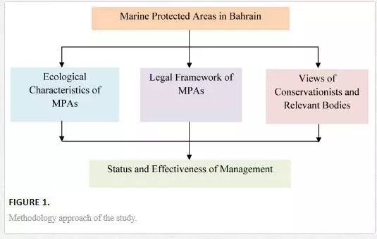
The methodological approach of the present study (Fig. 1) is composed of four dimensions:
(1) providing an ecological description for the regional and national coastal and marine ecosystems;
(2) investigating the ecological characteristics of the Bahraini MPAs by reviewing available published and gray literature;
(3) collecting in-field information related to the ecological conditions of MPAs in Bahrain;
(4) analyzing the legal framework of MPAs in Bahrain; and
(5) soliciting views of conservation practitioners, academics, and other relevant bodies about the importance of MPAs and their effectiveness in Bahrain using a semi-structured interview.
Ecological setting of the Arabian Gulf
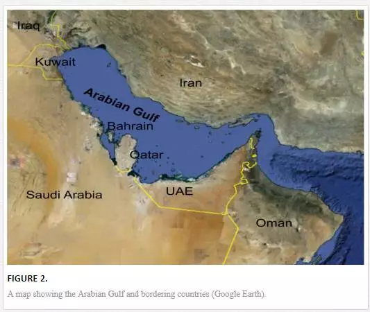
The Arabian Gulf is a semi-enclosed sea situated in the subtropical region of the Middle East (Fig. 2). It constitutes part of the Arabian Sea Ecoregion and represents a realm of the tropical Indo-Pacific Ocean. The Arabian Gulf is a relatively shallow basin with an average depth of 35 m. The marine environment of the Arabian Gulf is naturally stressed due to marked fluctuations in sea temperatures and high salinities. Sea temperatures can exceed a range of 20oC between winter and summer. Summer temperatures can exceed 35oC, making the Arabian Gulf the hottest sea on Earth [10]. The Arabian Gulf is also characterized by extreme salinities that exceed 44 psu in open waters and 70 psu in coastal lagoons. Therefore, marine flora and fauna inhabiting the Arabian Gulf are living close to the limits of their environmental tolerance [11]. Despite these extreme climatic conditions, the Arabian Gulf supports a wide range of coastal and marine ecosystems that contribute significantly to the productivity of marine resources, including seagrass beds, coral reefs, mangroves, and mudflats [12].
Anthropogenically, the Arabian Gulf is considered among the highest impacted regions in the world [13] due to intensive reclamation and dredging activities, industrial and sewage pollutants, hypersaline water discharges from desalination plants, and oil pollution [14]. Therefore, designation of MPAs is arguably critical for the protection of naturally stressed coastal and marine ecosystems in the Arabian Gulf. In relation to this, there are currently about 38 officially designated MPAs covering around 18,180 km2 in the Arabian Gulf [15]. However, several weaknesses in the MPAs in the Arabian Gulf were identified, including limitation in regulation enforcement, lack of management plans, weak communication with local stakeholders, traditional communities, and local marine resource users [9].
Coastal and marine biodiversity in Bahrain
The Kingdom of Bahrain consists of an archipelago of approximately 40 natural islands in addition to several islets, shoals, and patches of reefs, lying centrally on the southern shores of the Arabian Gulf between latitudes 25° 32' and 26° 20' north and longitudes 50° 20' and 50° 50' east. The general aspects of climate in Bahrain are cool winters (14−23oC) with moderate rainfall, and hot summers (26−40oC) with high humidity. The winter season in Bahrain is accompanied by rainfall with an average of approximately 74 mm per annum. The summer season is hot with a substantial increase in humidity due to the high rate of evaporation from the surrounding seawaters [16]. Salinities around Bahrain are generally high due to the effects of high temperatures associated with high evaporation rates. Salinities on the west coast are higher than those on the east coast, with average means of 50−57 psu for the west coast and 43−45 psu for the east coast. This variation in the salinity gradients may be attributed to a complex system of water circulation around Bahrain enforced by reduced water exchange, particularly in south of Bahrain, where salinity could reach 70−80 psu in areas with restricted water flow such as tidal pools and lagoons [17]. The total land area of Bahrain in 2012 is about 777 km2 [16]. Despite the limited land area of Bahrain, waters surrounding its islands support several Valued Ecosystem Components (VECs) such as seagrass beds, coral reefs, mangrove swamps, and mudflats that provide important ecological goods and services.
Seagrass beds are highly productive ecosystems that are characterized by important ecological and economic functions. They provide food sources and nursery grounds for turtles, dugongs, shrimps, and a variety of economically important marine organisms. Three species of seagrass occur in Bahrain, namely Halodule uninervis, Halophila stipulacea, and Halophila ovalis [18]. Dense seagrass beds (>75 coverage) mostly occur on sandy substrates. The majority of the seagrass habitats in Bahrain waters are located in the eastern subtidal areas, mainly from south of Fasht Al-Adhm to Hawar Islands. The second largest seagrass beds are found in the western subtidal areas of Bahrain [19].
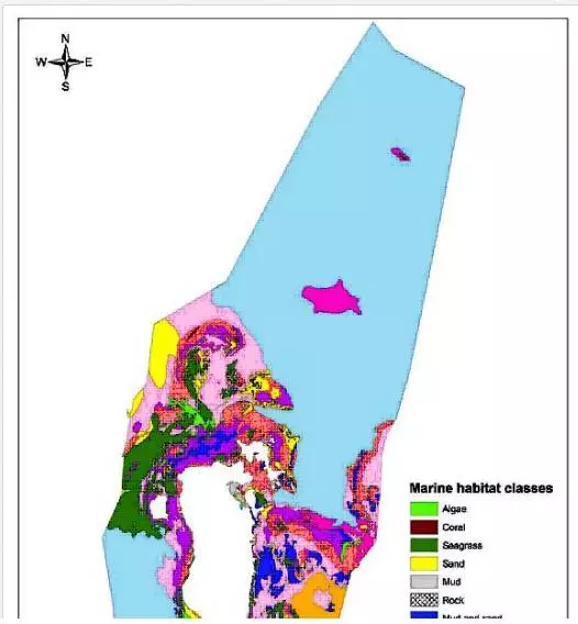
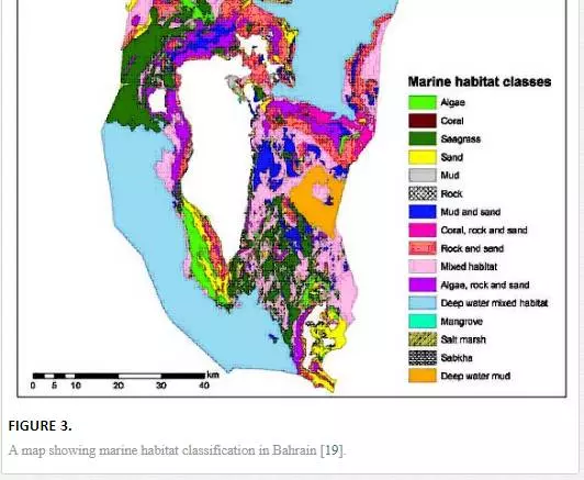
Coral reefs are characterized by both biological diversity and high levels of productivity. They provide a variety of ecological services such as renewable sources of seafood; maintenance of genetic, biological, and habitat diversity; recreational values; and economic benefits such as utilizing destructive reefs for creating land through the process of reclamation. Coral habitats are mainly restricted to the north and east of Bahrain. These include Fasht Al-Adhm to the east of Bahrain (the largest reef in Bahrain, 200 km2), Fasht Al-Jarim and Khor Fasht 20 km to the north, and Bulthama, 75 km northeast of Bahrain. Additionally, several other smaller reefs are scattered around eastern areas of Bahrain [19, 20]. Live coral cover in Bahrain is generally low, ranging from 5 to 16% [20]. This could be attributed to the massive bleaching events that occurred in the Arabian Gulf in the summers of 1996 and 1998. Bahrain was the worst affected by these events with an estimated overall loss of 97% of live corals [21].Mangrove habitats are ecologically important coastal ecosystems that provide food, shelter, and nursery areas for a variety of terrestrial and marine fauna. Natural mangrove plants, which are represented by a single species, Avicennia marina, can be found only in Tubli Bay. The largest aggregation of mangroves is confined to Ras-Sanad lagoon, which is the most sheltered area on the coast of Bahrain. This lagoon has characteristics that support the growth and development of mangrove plants, including minimal motion of the water, muddy nature of the substrate, and an input of low salinity water from nearby farms and underground springs [22]. Transplanted mangroves can be found in Duwhat Arad area, which is a small intertidal mudflat. Mudflats are among the most productive marine habitats that contribute significantly to the marine productivity in Bahrain. These habitats typically harbour large numbers of wintering and migratory shorebirds [23]. Mudflats in Bahrain are represented by low-energy areas on the northern and eastern coasts of Bahrain, as well as patches of sheltered lagoons within Hawar Islands. Recent marine habitat mapping in Bahrain revealed sixteen types of habitats in Bahrain, namely algae, coral, seagrass, sand, mud, rock, mangrove, salt marsh, sabkha, rock and sand, coral-rock-sand, algae-rock-sand, mud and sand, mixed habitats, deep water mud, and deep water mixed habitats. Figure 3shows the distribution of these marine habitats based on the Marine Atlas of Bahrain [19].
Institutional governance of conservation in Bahrain
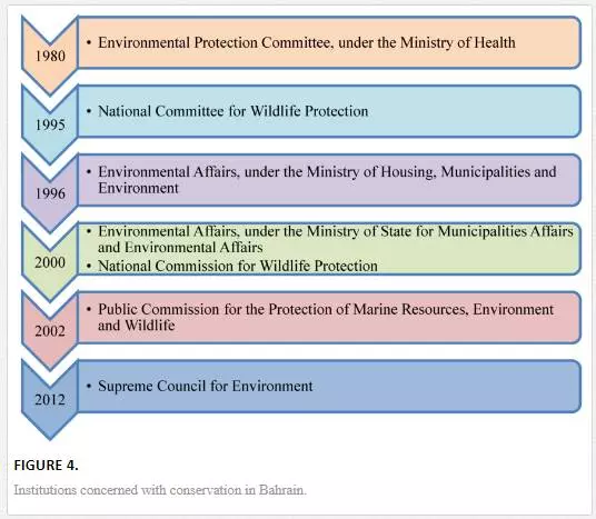
This section provides a brief overview of the institutional governance of conservation in Bahrain, which will provide a context for analyzing the legal framework of MPAs. The Environmental Protection Committee (EPC), established by Decree No. 7 of 1980 under the Ministry of Health, was the first governmental authority concerned with protection of environment in Bahrain. The EPC was upgraded by the Legislative Decree No.21 of 1996, establishing Environmental Affairs under the Ministry of Housing, Municipalities and Environment. In 2000, the Environmental Affairs was reorganized under the Ministry of State for Municipalities Affairs and Environmental Affairs. A second governmental body concerned with wildlife protection is the National Committee for Wildlife Protection, which was established by the Legislative Decree No. 2 of 1995. This committee was upgraded to become the National Commission for Wildlife Protection by the Legislative Decree No 12 of 2000.For the purpose of integration of efforts and resources to achieve an effective protection for the environment, the main governmental bodies concerned with the environment were joined under the umbrella of the Public Commission for the Protection of Marine Resources, Environment and Wildlife (PCPMREW) in 2002. The PCPMREW was established by the Legislative Decree No. 50 of 2002 and reorganized further by Legislative Decrees No. 10 and No. 43 of 2005.
More recently (2012), the Supreme Council for Environment (SCE) was established by the Legislative Decree No. 47 of 2012. The SCE forms the foundation to strategically integrating biodiversity considerations among all governmental and private sectors in Bahrain. The Legislative Decree with respect to Establishing and Organizing the Supreme Council for Environment explicitly indicates that decisions of the Council are binding to all ministries, authorities, and institutions in the Kingdom. Figure 4 shows the chronological development of environmental bodies in Bahrain.
Marine protected areas in Bahrain
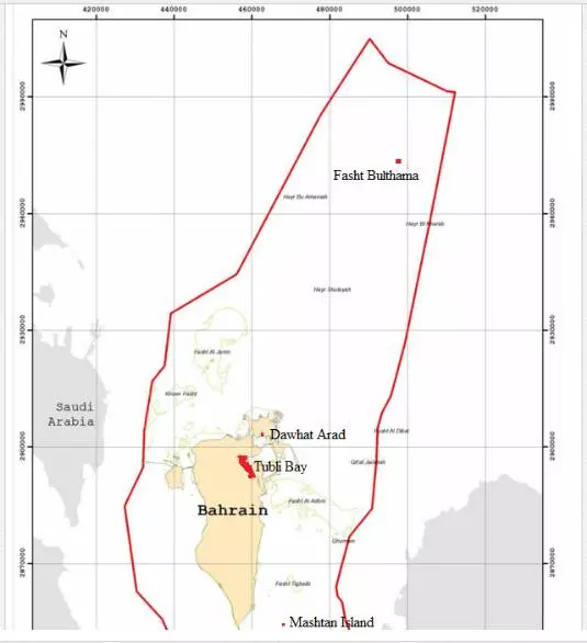
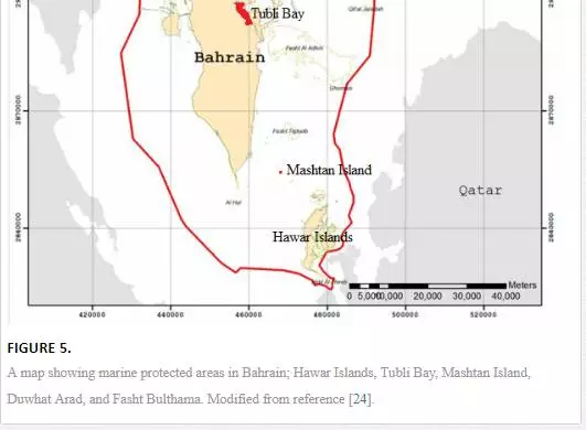
Coastal and marine environments in Bahrain are characterized by regionally and globally important habitats, including seagrass beds, coral reefs, and mangroves. Additionally, waters surrounding Bahrain support some of the most endangered species such as dugongs and turtles. These ecosystems maintain genetic and biological diversity and contribute to food security for the region. However, these ecosystems are vulnerable to environmental extremes in the Arabian Gulf and susceptible to the increasing anthropogenic stressors from the rapid economic and industrial developments in Bahrain. Therefore, protecting these fragile ecosystems is a priority in Bahrain. Designating marine protected areas is considered as a key strategy to protect coastal and marine ecosystems in Bahrain. Toward this, there are currently five designated natural marine protected areas in Bahrain, namely Hawar Islands, Tubli Bay, Mashtan Island, Duwhat Arad, and Fasht Bulthama (Fig. 5).
HAWAR ISLANDS
ECOLOGICAL CHARACTERISTICS
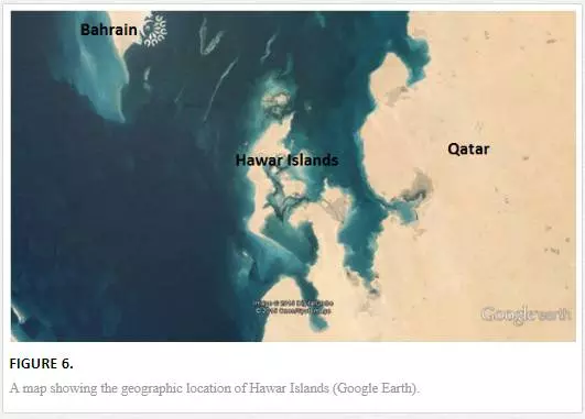
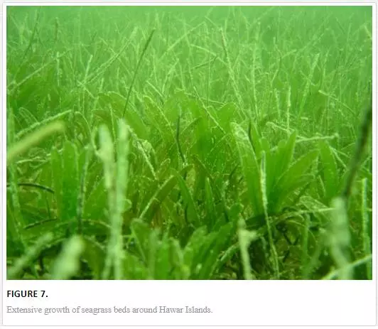
The archipelago of Hawar Islands (581 km2), which is located in the Gulf of Bahrain (Fig. 6), is characterized by varied coastal habitats, including muddy, sandy, and rocky shores as well as saline wetlands. These islands are surrounded by shallow waters (average depth 2 m) that promote the growth of extensive seagrass beds and algal mats (Fig. 7). Waters surrounding Hawar Islands support vulnerable species such as dugongs, turtles, and dolphins. For instance, seagrass beds between Bahrain and Hawar Islands support a large population of the globally threatened dugongs (Dugong dugong) with an estimated 5,800 individuals. This population of dugongs is considered the largest one known outside Australia [25]. Similarly, significant populations of green turtles and dolphins depend on these seagrass beds, and their associated fish as feeding grounds [26].
Hawar Islands are vastly important for seabirds. These islands host the World’s largest breeding colony of Socotra Cormorants (Phalacrocorax nigrogularis), with a winter population of 200,000 individuals [27]. Additionally, they are a breeding area for many other important seabirds, including western reef herons (Egretta gularis) and terns (Sterna caspia, Sterna repressa, Sterna anaethus, Sterna bengalensis). These islands are also important as a feeding and roosting area for many migratory seabird species such as greater flamingos (Phoenicopterus ruber), seagulls (Larus genei and Larus argentatus), and several waders (Calidris minuta, Calidris alba, Calidris ferruginea, Calidris alpina) [27, 28]. The islands also host endangered and vulnerable birds, such as the sooty falcon (Falco concolor) and Ospreys (Pandion haliaetus) [27]. Intertidal sand and mudflats of the Hawar Islands are characterized by rich and diverse macrobenthic assemblages. For instance, a baseline ecological survey for the main island revealed a total of 119 species of macrobenthic assemblages [29].
NATIONAL AND INTERNATIONAL LEGAL PROTECTION
Hawar Islands are characterized by a complex of ecological habitats, including seagrass beds, algal mats, sand, and mudflats. Additionally, these islands are home to distinctive populations of flora, mega-fauna (i.e., dugongs, turtles, and dolphins), and avifauna. Therefore, Hawar Islands are under national and international designations. Nationally, Hawar Islands were declared as a wildlife sanctuary by the Prime Minister Order No. 16 of 1996 with respect to Declaration of Hawar Islands and their Territorial Waters as a Protected Area. This designation was in accordance to the Legislative Decree No. 2 of 1995 with respect to the Protection of Wildlife.The objectives of the Prime Minister Order were the protection of the terrestrial and marine natural habitats and their wild species of Hawar Islands and the protection of rare and endangered species. Several subsequent regulations were issued to support the protection of Hawar Islands, including the Ministerial Order No. 6 of 1996 with respect to the recommendations of the National Commission for Wildlife Protection Related to Hawar Islands and their Territorial Waters. This order prevents all forms of fishing around Hawar Islands and their territorial waters and only allows the use of traditional fishing gear such as hadrah (an intertidal fixed stake trap), cages, and trolls. This order also prevents taking eggs or chicks of breeding birds, including Falco concolor, Pandion haliaetus, Phalacrocorax nigrogularis, Sterna repressa, and Egretta gularis.
Fishing around Hawar Islands was regulated by the Order of the Public Commission for the Protection of Marine Resources, Environment and Wildlife No. 13 of 2005 with respect to the Regulation of Fishing in Hawar Islands and their Territorial Waters. This order prohibits fishing in commercial quantities and overfishing around Hawar Islands and their territorial waters. It also prevents the use of any tools, machines, or materials that can pose a threat to the marine resources in the region. The order allows the use of the traditional fishing gears (i.e., hadhrah, cages, trolls). However, an amendment of this order based on the Order No. 4 of 2010 restricts the use of hadhrah to a license from the General Directorate for the Protection of Marine Resources.
Internationally, Hawar Islands were designated as a Ramsar site (Convention on Wetlands of International Importance) in 1997 due to the abundance of globally significant, rare, and endangered bird species.
TUBLI BAY
ECOLOGICAL CHARACTERISTICS
Tubli Bay (Fig. 8), located in the northeast of Bahrain, is a sheltered coastal body that supports a variety of habitats, including mudflats, seagrass beds, algal mats, mangrove swamps, and patches of rocky shores. Tubli Bay is a productive shallow bay that forms an important nursery ground for several commercial fish species and prawns [30]. Additionally, it provides important feeding and roosting grounds for large numbers of wintering and migratory shorebirds. Several wader species were recorded in the bay, including Ardea cinerea, Arenaria interpres, Calidris minuta, Charadrius alexandrinus, C. hiaticula, C. mongolus, Egretta garzetta, Gallinula chloropus, Himantopus himantopus, Larus ichthyaetus, L. ridibundus, L. genei, Limicola falcinellus, and Pluvialis squatarola [28, 31].
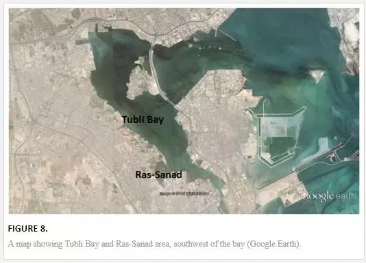
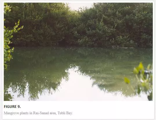
Tubli Bay hosts the last standing natural mangrove ecosystems in Bahrain (Fig. 9). Mangroves, Avicennia marina, are confined to few patches of sheltered muddy areas along the coastline of the bay. The main aggregation of mangroves is found in Ras-Sanad area (0.5 km2), southwest of the bay. Water and sediment characteristics at Ras-Sanad area support the growth and development of mangrove plants [22]. Studies investigating the benthic community structure in Tubli Bay revealed a significant role of mangrove plants in maintaining diversity and productivity of marine benthos [32, 33].
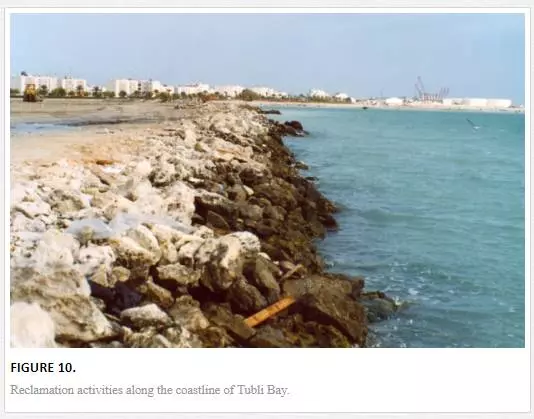
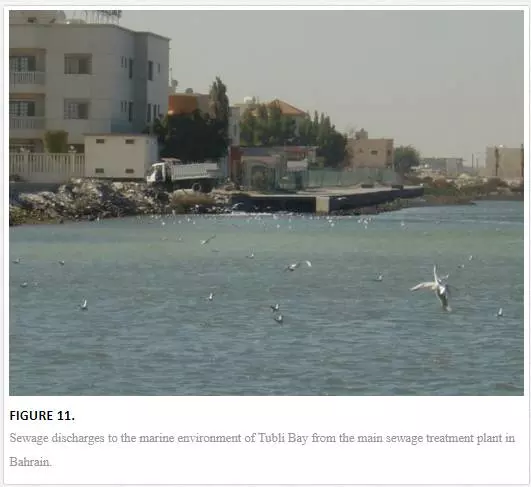
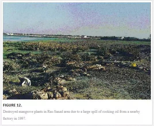
Tubli Bay has been under pressure from several human activities. These include reclamation and dredging activities (Fig. 10) and sewage discharges (Fig.11) from the main sewage treatment plant in Bahrain. The marine area of Tubli Bay has been reduced from 25 to 12 km2 in 2008 due to intensive reclamation activities. These activities significantly destroyed mangrove stands and reduced their spatial distribution. Historically, mangrove stands were densely dominant on the coastline of Tubli Bay [33]. However, due to coastal development and pollution, mangrove stands have progressively reduced over the years (Fig. 12). Recently, a study investigating the composition of mangrove plant community in Tubli Bay during the years 2005 and 2010 indicated that the current area of mangroves is around 0.31 km2 [34].
NATIONAL AND INTERNATIONAL LEGAL PROTECTION
The mangroves in Ras-Sanad areas were declared as a nature reserve by the Environmental Protection Committee in 1986. Tubli Bay was declared as a protected area in 1995 based on the Ministerial Order No. 1 of 1995 with respect to Banning of Reclamation in Tubli Bay. This order explicitly prohibits construction activities in the mangrove area in Ras-Sanad as it is considered as a nature reserve category (a) in accordance with the Council of Ministers’ decision dated April 16, 1995. The order also prevents construction activities in the remaining area of Tubli Bay as it is considered as a nature reserve category (b) in accordance with the same decision of the Council of Ministers.Law No. 53 of 2006 with respect to the Declaration of Tubli Bay as a Natural Protected Area was issued to prevent the unsustainable reclamation activities along the coastline of Tubli Bay. This law considers Tubli Bay as natural protected area (Natural Park) and stresses on stopping all types of reclamation and dredging activities in the Bay. The law also directs all the competent governmental authorities to take all necessary measures to protect the environment and wildlife in the bay. This was followed by the Ministerial Order No. 70 of 2011 with respect to Determination of the Reclamation Line in Tubli Bay. This order specifies the final line of the marine area of the bay. Internationally, Tubli Bay was designated as a Ramsar site in 1997 for birds.
MASHTAN ISLAND
ECOLOGICAL CHARACTERISTICS
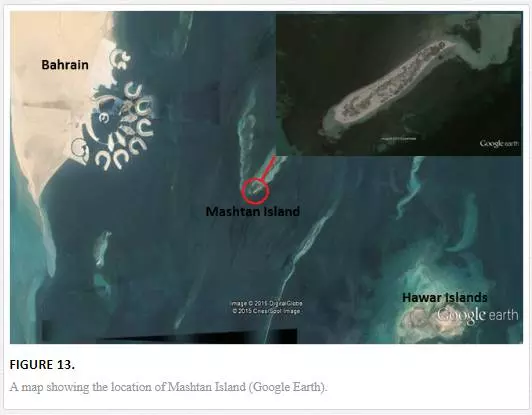
Mashtan is a small offshore sandy island (0.2 km2) located between Bahrain and Hawar Islands (Fig. 13). Waters surrounding this island are characterized by widespread growth of seagrass beds that provide feeding grounds for many species, including dugongs and sea turtles. Additionally, the surrounding environment is characterized by the presence of mixed habitats, including scattered coral reefs and patches of sand and mudflats [19].
NATIONAL PROTECTION
Mashtan Island is nationally protected based on the Order of the National Commission of Wildlife Protection No.1 of 2002 with respect to the Declaration of Mashtan Island as a Protected Area. The designation of Mashtan Island as a protected area is based on the general policy of the government to protect terrestrial and marine habitats and their associated organisms.
DUWHAT ARAD
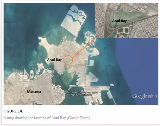
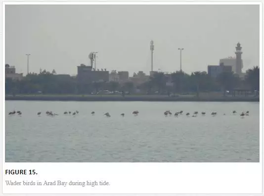
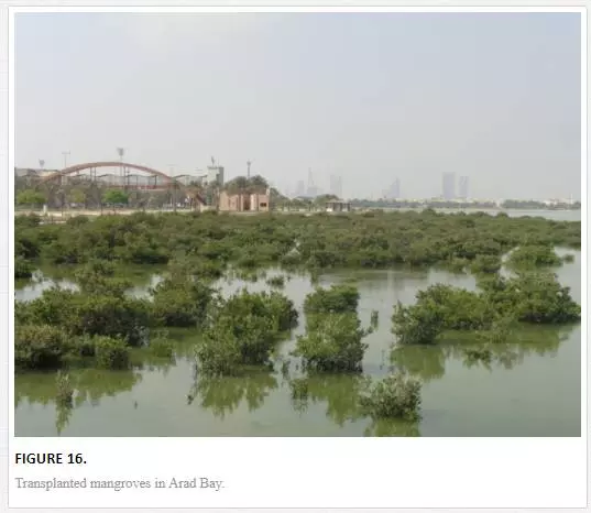
Duwhat Arad is a sheltered bay (0.5 km2) located in the northeast of Bahrain (Fig. 14). The bay is a shallow mudflat that forms an important ground for feeding and roosting of important shorebirds, including Charadrius alexandrinus, Charadrius hiaticula, Egretta gularis, Himantopus himantopus, Larus ridibundus, and Phoenicopterus ruber (Fig. 15). Duwhat Arad has been an inshore area of great economic, ecological, and scientific importance that warrants the designation as a protected area [23]. Several mangrove stands of Avicennia marina have been transplanted in the bay (Fig. 16). Although the transplanted mangrove plants are found in relatively stunted forms, they contribute to the productivity in the bay. Duwhat Arad is protected based on The Public Commission for the Protection of Marine Resources, Environment and Wildlife Order No. 4 of 2003 with respect to the Declaration of Duwhat Arad as a Marine Protected Area.
HAYR AND FASHT BULTHAMA
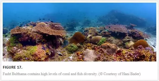
Fasht Bulthama contains the healthiest corals in Bahraini waters (Fig. 17). This reef is characterized by relatively high levels of coral diversity (22 species) and coral cover (16.3%) [20]. The reef is surrounded by pearl oyster banks characterized by high abundance of the pearl oyster (Pinctada sp.). The reef and the oyster banks represent a hub for high fish stocks. Hayr and Fasht Bulthama are protected based on the Order of the Public Commission for the Protection of Marine Resources, Environment and Wildlife No. 8 of 2007 with respect to the Declaration of Hayr Bulthama Area as a Natural Marine Protected Area. This order bans trawling and the use of nets in this protected area.
Views of conservationists on the effectiveness of MPAs in Bahrain
Views of conservationists, environmentalists, and other relevant bodies related to the effectiveness of marine protected areas in Bahrain were solicited using semi-structured interviews. The target population for the interviews consisted of members from the Supreme Council for Environment (1), academic institutions (8), and environmental consulting firms (2). They are experts in several fields related to biology conservation, including marine ecology, marine biology, environmental biology, and environmental management. Additionally, selected graduates (5) who completed a course in conservation biology at the Department of Biology, University of Bahrain were included in the interviews. The interviewees were asked for their views and experience in reference to the effectiveness of the five designated natural marine protected areas in Bahrain. The contents of the semi-structured interviews were derived from the Marine Protected Area Score Card [36]. This score card is a simple questionnaire that depends on the use of existing knowledge and information from academics, local scientists, or experts. It is composed of six main headings reflecting the stages of marine protected area management proposed by the International Union for Conservation of Nature (IUCN). These stages include context, planning, inputs, processes, outputs, outcomes. The score card comprises 34 main questions under the mentioned stages related to legal status and regulation of MPA, threats to MPA, monitoring of MPA, stakeholder engagement and awareness, objectives of MPA, management plan, research, and communication. However, some of these questions were modified or merged to accommodate the environmental and legislative contexts, and regularity frameworks in Bahrain.
A comprehensive and enforced legislation framework is a key pillar for the success of any MPA. Generally, the five MPAs in Bahrain are legally designated (i.e., gazetted). Two of these MPAs (Hawar Islands and Tubli Bay), are internationally designated as Ramsar sites. There are supplementary regulations for Hawar Islands and Tubli Bay that can further enhance their legal status. Nonetheless, these regulations might be constrained by the limited enforcement and implementation. The designation orders of Mashtan Island, Dawhat Arad, and Fasht Bulthama contain limited information related to the MPAs’ objectives, management, and boundaries. Although the MPAs’ objectives and boundaries might be known by the environmental authority, it is critically important to define them for relevant stakeholders and the public. For instance, the boundaries surrounding Hawar Islands, Mashtan Island, and Fasht Bulthama are not clearly defined. Human and financial resources are critical for the success of any conservation initiative. The establishment of the Directorate of Biodiversity at the Supreme Council for Environment in 2012 is a major step forward to strengthen the institutional capacity in protecting biodiversity in Bahrain. However, most of the interviewees indicated that the Directorate of Biodiversity might be understaffed with limited budget, which could affect the implementation of major ongoing conservation programs. For instance, The Supreme Council for Environment has finalized a detailed plan to ecologically rehabilitate the mangroves in Ras-Sanad area. However, limited financial resources are hindering such initiatives.
Globally, MPAs are increasingly exposed to a wide range of anthropogenic threats. Reclamation and dredging, industrial and sewage effluents, hypersaline water discharges from desalination plants, and oil pollution are examples of anthropogenic stressors that may affect the MPAs in Bahrain [37]. The remote locations of Hawar Islands and Fasht Bulthama make them less vulnerable to human disturbance. However, these two MPAs are affected by overfishing. Several interviewees confirmed the intensive fishing activities in Hawar Islands and Fasht Bulthama. Mashtan Island is susceptible to sedimentation due to dredging and reclamation activities south of Bahrain. Avifauna in Arad Bay might be affected by intensive recreational activities. Tubli Bay is mainly affected by reclamation activities and sewage pollution. Reclamation has been more marked in Tubli Bay. This bay has nearly lost 50% of its original marine area. Reclamation activities in the bay have resulted in a loss of many mangrove stands, mudflats, and rocky patches. Excessive nutrient enrichment due to the continuous discharge of domestic sewage to the shallow marine area of the bay has resulted in several eutrophication incidents. Generally, all interviewees agreed that there are limited comprehensive mechanisms to control or limit human activities affecting MPAs in Bahrain.
A successful MPA depends on knowledge-based decision making, where scientific research is integrated into management actions [38]. Studies investigating marine protected areas and their associated ecosystems in Bahrain have included surveys of marine benthic assemblages in Tubli Bay [30, 32, 33, 39, 40], ecological aspects and spatial distribution of mangroves [35, 41, 42], physiological aspects of mangroves [22], microbial communities in Ras-Sanad area [43], ecological surveys for Hawar Islands [29, 44], coral cover in Fasht Bulthama [20], avifauna distribution in Tubli Bay and Arad Bay [23, 28, 31], environmental assessment for Tubli Bay [45], heavy metal contamination in Tubli Bay [46], and the selection of marine protected areas in Bahrain [47]. This latter publication [47] is considered the most comprehensive study detected to prioritize candidate MPAs based on ecological and socioeconomic criteria using a Geographic Information System (GIS). Despite their importance, these studies are rarely referred to in the decision-making process related to MPAs in Bahrain as agreed by most of the interviewees.
Monitoring physical, chemical, and biological aspects of MPAs can provide decision makers with information on the state of biodiversity, and consequently, assist in identifying management goals and assessing priorities for conservation [48]. It was agreed by interviewees that information on the biophysical, sociocultural, and economic conditions associated with MPAs in Bahrain is not sufficient to support planning and decision-making process. Generally, adequate monitoring programs for MPAs in Bahrain are limited. Some of the interviewees argued that the main Universities in Bahrain (University of Bahrain and Arabian Gulf University) have the scientific and technical capabilities to conduct integrated monitoring programs for the MPAs in Bahrain. Toward this end, the University of Bahrain has conducted two major ecological surveys for Hawar Islands in support of sustainable development in these islands. However, such monitoring programs are hindered by limited financial resources. For instance, an interviewee indicated that a proposed study by the University of Bahrain to conduct an integrated environmental assessment for Arad Bay, which could result in formulating a management plan for the bay, is awaiting financial support from concerned environmental authority in Bahrain. Understanding of MPAs’ objectives by local communities is recognized as a key for the success of conservation initiatives [49]. Further, public participation in the designation process is important for effective implantation of regulations and management plans. Knowledge and attitudes of local communities toward marine protected areas in Bahrain were investigated by a recent study [50] using a questionnaire survey. This study reported an agreement (95%) among the surveyed population with respect to the need for MPAs in Bahrain. However, only 55% of the respondents indentified all the MPAs in Bahrain. This highlighted the need for more systematic measures to increase environmental awareness related to MPAs in Bahrain among stakeholders and the public. Most of the interviewees stressed the need to further incorporate conservation aspects in schools’ curricula, and to increase awareness programs through different sources of media.
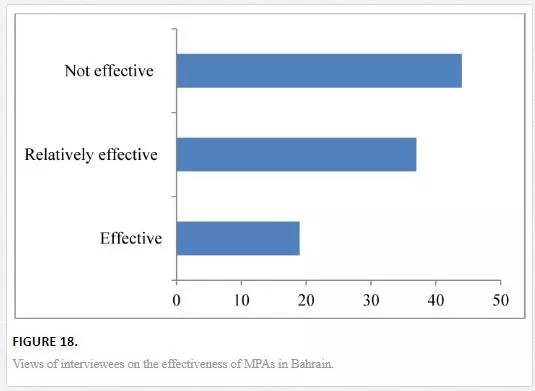
Education plays an important role in capacity building related to conservation biology in Bahrain. Toward this end, a course in conservation biology was introduced at the Department of Biology, University of Bahrain in 2009. This course explores the principles of conservation biology, including biological diversity and its value, threats to biological diversity, conservation at the population and species levels, and management of habitats and ecosystems. The course discusses aspects of biodiversity conservation in Bahrain. Several graduate students skilled in knowledge relating to conservation biology joined relevant institutions. Although such initiatives should reflect positively in capacity building related to conservation biology, most of the interviewees stressed the need for systematically introducing the biodiversity concerns into the higher education institutions in Bahrain.Generally, there is an assumption among the interviewees that indicated that the effectiveness of MAPs in Bahrain could be improved by taking necessary legislative and management actions. Around 19% viewed MPAs in Bahrain as being effective. This was mainly attributed to the relatively stable ecological conditions in Hawar Islands and Fashit Bulthama. Nearly 37% of the interviewees emphasized that there are increasing signs of ecological and environmental degradation in the MPAs and deemed them relatively effective. Conversely, a large proportion of the interviewees (44%) indicated that MPAs are not effective under the current marine conservation system in Bahrain (Fig. 18). They attributed this to the increasing evidence of further degradation in the mangroves in Ras-Sanad area, the increasing of human activities in Arad Bay that may be limiting wintering waders from using the mudflats and the increasing of overfishing activities in Hawar Islands and Fasht Bulthama that could compromise their ecological integrity.
Challenges and the way forward
The effectiveness of any MPA lies in its ability to support viable long-term populations; especially for vulnerable and endangered species and to maintain healthy ecosystems. MPAs in Bahrain are contributing to the protection of critical coastal and marine habitats and their associated flora and fauna. However, there are several constraints that may restrict the effectiveness of the MPAs in Bahrain. These include limitation in regulation enforcement, lack of comprehensive management plans, and limitation in participation of stakeholders and local marine resource users in the designation process.
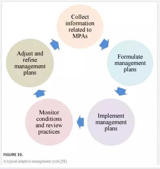
Adaptive management, which is a structured and iterative management process, could be suggested as a measure to enhance the effectiveness of MPAs in protecting coastal and marine ecosystems in Bahrain. Adaptive management is composed of several stages, including collecting information related to MPAs from different sources, formulating and implementing management plans, and adjusting and refining management plans based on the outcomes from monitoring and practices. Figure 19 illustrates a typical adaptive management cycle [51].
Findings of this study indicate that there are yet further needs to strengthen efforts on conserving coastal and marine environments in Bahrain. Recommendations that may contribute to enhancing the effectiveness of MPAs in Bahrain might include:
· Characterizing the current biological, ecological, legal, social, and economic conditions of MPAs in Bahrain;
· Collecting information related to MPAs in Bahrain from all relevant bodies, including environmental authorities, stakeholders, scientists, and the general public;
· Consulting best currently available scientific knowledge related to MPAs in Bahrain to support decision making and management;
· Conducting studies to assess provisioning, supporting, and regulating cultural goods and services provided by coastal and marine ecosystems in Bahrain;
· Linking ecosystem services and human well-being, which will lead to a better understating of the importance of MPAs by decision makers, stakeholders, and the public;
· Formulating comprehensive management plans for MPAs in Bahrain;
· Incorporating concerns of all relevant stakeholders in the management plans;
· Defining clearly the conservation objectives, individually and collectively, of MPAs in Bahrain;
· Specifying the boundaries of MPAs in Bahrain;
· Formulating strategies to address human threats to MPAs in Bahrain;
· Implanting and enforcing the management plans in cooperation with all relevant stakeholders;
· Designing integrated monitoring programs that allow evidence-based decision making regarding MPAs in Bahrain;
· Encouraging scientific research and providing necessary financial resources;
· Incorporating conservation aspects in the curricula of schools and universities;
· Amending relevant MPAs legislations;
· Allocating human and financial resources to accomplish conservation initiatives;
· Strengthening the institutional and legal capacity of the Biodiversity Directorate at the Supreme Council for Environment;
· Increasing public awareness about ecosystem services and the role of MPAs.
Challenges of marine conservation in Bahrain can be extended to the whole region of the Arabian Gulf [9]. Regional network of MPAs could assist in protecting the fragile ecosystems of the Arabian Gulf. Therefore, further cooperation between local and regional institutions and organizations concerned with MPAs, scientific research, and environmental monitoring is required. In this respect, the Regional Organization for the Protection of the Marine Environment (ROPME) can play an important role in coordinating the efforts of marine conservation in the Arabian Gulf.
Conclusion
The marine environment in Bahrain supports a variety of habitats such as seagrass beds, coral reefs, mangroves, and mudflats. In addition to their intrinsic value and role in maintaining biodiversity, these ecosystems provide important ecological, economic, and cultural services to communities in Bahrain. Marine resources including fisheries provide sources of income, employment, and recreation, and contribute to the cultural heritage and food security. Bahrain has recognized the importance of marine biological and environmental resources and the need to protect them. MPAs are the most advocated approach for marine conservation. Several MPAs have been established to protect representative sensitive habitats in Bahrain, including offshore islands surrounded by extensive seagrass beds, mangroves swamps, coral reefs, and mudflats. However, these MPAs are influenced by anthropogenic stressors that may affect their ecological integrity, including reclamation and dredging, industrial and sewage effluents, oil pollution, and overexploitation. Effective management of MPAs in Bahrain is restricted by limitation in enforcement of relevant laws, lack of comprehensive management plans, and limitation in financial resources. Adopting integrated adaptive management approach, and promoting scientific research, education, and environmental awareness can enhance the effectiveness of MPAs in protecting coastal and marine ecosystems in Bahrain.