Salient features of world’s physical geography
Earth is splendid terrestrial haven. It is imperative to know physical geography through its display of environmental diversity. In scientific studies, it is established that Geography is a word that originated from two Greek roots. Geo-denotes to “Earth,” and graphy stands for “picture or writing.” Geography is the study of earth as the home of present day human being (Sagmit, 1998).The main objective of geography is the assessment, and explanation of Earth, its variability from place to place, the way places and features transform over time, and the processes responsible for these variations and changes. Geography is termed as the spatial science because it incorporates recognizing, analysing, and explaining the variations, similarities, or differences in phenomena situated on the surface of Earth. Geography is unique among the sciences by virtue of its characterization and central purpose. It describes the values and attitudes towards environment and sharpen intellectual and practice skill.
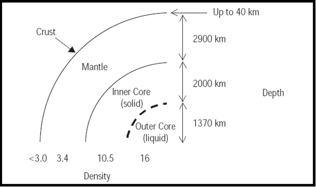
Earth’s structure is divided into three zones that include crust, Mantle and core. Crust is the solid outer layer of the Earth, and its depth is usually never more than 1 per cent of the Earth’s radius, or averaging 40–50 km, but this varies significantly around the sphere. These are two different types: oceanic and continental. Mantle is the region within the Earth’s interior that range from 25 to 70 km below the surface, to a depth of ~2,900 km. It is composed mainly of silicate rocks, rich in iron and magnesium. At the base of the mantle, temperatures may reach up to 5,000°C. These high temperatures may help to generate convection currents which drive plate tectonics. Core is the very centre of the Earth and is composed of iron and nickel. It consists of an outer core (semi-molten) and inner core (solid). The temperature at the very centre of the Earth (~6,300 km below surface) may reach 5,500°C.
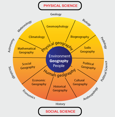
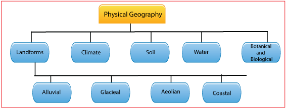
Geography is inherently encompassing discipline. It brings together facts from other sciences such as physical biological and social. Physical geography is related to the physical science. Physical geography includes the processes and attributes that constitute Earth which incorporate human activities where they interface with the atmosphere. Different branches of Physical geography are climatology, Meteorology, Geomorphology and pedageography (Sagmit, 1998).
Scientific studies have revealed that physical geographers are more interested in comprehending all aspects of Earth and can be considered generalists because they are qualified to scrutinize a natural environment in its entirety, and how it functions as a unit. In physical geography, researchers study about lithosphere, atmosphere, hydrosphere, and biosphere. Due to interaction of these elements, numerous changes occur on earth surface. Most physical geographers concentrate on advanced study in one or two specialties. For instance, meteorologists and climatologists believe how the interaction of atmospheric components influences weather and climate. Meteorologists focus their studies learning the atmospheric processes that affect daily weather, and they use current data to predict weather conditions. Climatologists are interested in the averages and extremes of long-term weather data, regional classification of climates, monitoring and understanding climatic change and climatic hazard, and the long term impact of atmospheric conditions on human actions and the surroundings.
The study of the nature, development, and modification of landforms is a field of geomorphology, a major sub field of physical geography. Geomorphologists are excited to know and elucidate variation in landforms, the processes that produce physical landscapes, and the nature and geometry of Earth’s surface features. The factors involved in landform development are as varied as the environments on Earth, and include gravity, running water, stresses in the Earth’s crust, flowing ice in glaciers, volcanic activity, and the erosion or deposition of Earth’s surface materials. Biogeographers scrutinize natural and human-modified environments and the ecological processes that influence their characteristics and distributions, including vegetation change over time. They also research and explain the ranges and patterns of vegetation and animal species, seeking to find out the environmental factors that limit or facilitate their distributions. Several soil scientists are geographers, who are concerned in mapping and analysing soil types, determining the aptness of soils for certain uses, such as agriculture, and working to conserve soil as a natural resource. Geographers are broadly concerned to study water bodies and their processes, movements, impact, quality, and other features. They may serve as hydrologists, oceanographers, or glaciologists. Many geographers involved with water studies also function as water resource managers, who work to ensure that lakes, watersheds, springs, and groundwater sources are suitable to meet human or environmental needs, provide an adequate water supply, and are as free of pollution as possible. Hydrology is merging science. It helps to understand the processes in which water plays an important role in nature through oceans, rivers and glaciers in sustaining life forms of earth surface.
Geographic knowledge and studies often start with locational information. The location of a feature usually uses one of two methods: such as absolute location, which is articulated by a coordinate system (or address), or relative location, which recognizes where a feature exists in relation to something else, usually a fairly well-known location.
Physical geographers are more concerned in exploring the environmental features and processes that merge to make a place unique, and they are also involved in the shared characteristics between places. Another feature of the characteristics of places is analysing the environmental benefits and challenges that exist in a place. When there is a need to know how features are arranged in space, geographers are generally engrossed in two spatial factors. Spatial distribution means the extent of the area or areas where a feature exists. Spatial pattern denotes to the arrangement of features in space that are regular or random, clustered together or broadly spaced.
It is well established that Earth’s features and landscapes are constantly changing in a spatial context. Weather maps demonstrate where and how weather elements change from day to day, over the seasons, and from year to year. Storms, earthquakes, landslides, and stream processes change the scenery. Coastlines may change position because of storm waves, tsunamis, or changes in sea level. Areas that were once forested have been clear-cut, changing the nature of the environment there.
The main interest of Geographers is to comprehend the physical and human characteristics of places, seeking to identify and explain characteristics that two or more locations may have in common as well as why places vary in their geographic attributes. Geographers collect, systematize, and analyse different types of geographic data and information, yet a unifying factor among them is a focus on explaining spatial locations, distributions, and relationships. They use array of skills, techniques, and tools to respond geographic questions. Geographers also study processes that influenced Earth’s landscapes in the past, how they continue to affect them today, how a landscape may change in the future, and the significance or impact of these change.
When appraising the geography of world, it is recognized that there are seven continents on Earth which include Africa, Antarctica, Asia, Australia, Europe, North America, and South America. Each has its own unique intermingle of physical features such as mountains, deserts, plains, valleys, forests, and bodies of water. In all over world, Latitude, landforms, and nearness to bodies of water greatly affect climate. Landforms, soil, and climate significantly influence the plants and animals that can be found in each place.
North America is ranked as third largest continent in area in the world. It is situated in the Western Hemisphere, it extends from near the North Pole southwards almost to the equator. It covers the territory between the Atlantic and Pacific Oceans from east to west. Central America, North America is surrounded by the Atlantic, Pacific, and Arctic Oceans. South of Mexico, the land narrows into Central America. Central America links North America to South America. Although Central America contains far less than 1% of the Earth’s surface, it has 7% of the world’s biodiversity that include various plants and animals. West Indies is in Northeast of Central America composed of a huge number of islands in the Caribbean Sea. Physical Features of this region of the world include mountains, water bodies, and rain forests. Major mountain ranges found in North America include the Rocky Mountains to the west and the Appalachian Mountains to the east. The Rocky Mountains expand northward into Canada and southward into Mexico. Main feature of Bodies of Water is the St. Lawrence River which separates parts of the United States from eastern Canada. The Mississippi River flows in much of the United States.
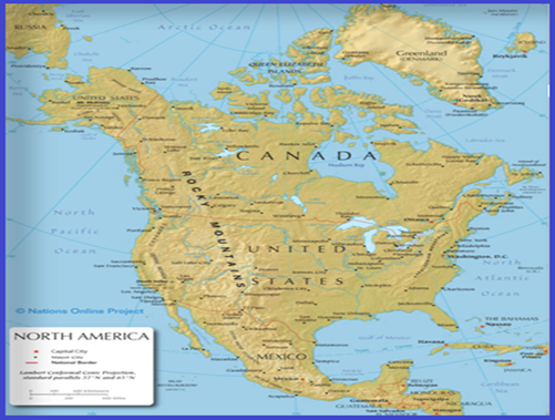
The Great Lakes include Lake Superior, Lake Michigan, Lake Huron, Lake Erie, and Lake Ontario form the biggest system of fresh water on Earth. The Rio Grande detaches the United States from Mexico. The Panama Canal, located in Central America, connects the Atlantic and the Pacific Oceans. Areas of Plains include west of the Mississippi River, a region known as the Great Plains, containing some of the world’s most productive farmland, Rainforests. Much of Central America and the islands of the West Indies have warm, humid climates and rainforests.
Another important region of world is South America which is sited in the Western Hemisphere south of Central America. South America is considered as the fourth major continent in area. It extends over 7,000 miles in length, it lies between the Atlantic and Pacific Oceans. Physical Features of this region include Mountains, Grasslands and Plains and others. The Andes Mountains are among the uppermost in the world. They lengthen over 4,500 miles in the western part of South America. The Andes were once the foundation of the Inca Empire. Grass lands and Plains are also important part of this region. Mountains and poor soils are unproductive in South America. One exception is the pampas of Argentina and Uruguay. The pampas give large areas of productive soil to grow crops and grazing cattle. Another physical feature of South America is Rainforests. Rainforests are situated on the east coast of Central America and the northern part of South America. Climatic conditions in this area are warm and humid. The vegetation closely reflects the climatic conditions in this continent. There are numerous vegetation as the major types of climate. The six Amazon Rainforests are the world’s biggest tropical rainforest in Brazil. Thousands of different varieties of trees are found here. Tropical grasslands are found in Venezuela, Guianas and South Brazil. Tropical grasslands are called Savannas. The prevailing vegetation consists of coarse grass varying heights. There is Mediterranean vegetation. The summer droughts and winter rains in central Chile produce a drought resisting vegetation having thick leaves and long roots.
Physical features of South America 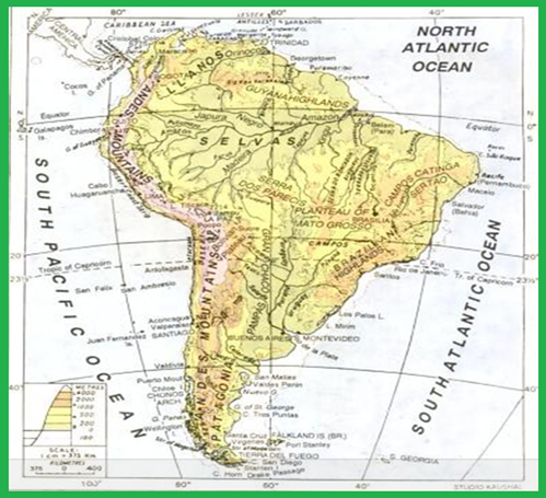
Every year, there is deforestation to provide land for ranches and farms. Bodies of Water in South America include The Amazon River which is the second longest river in the world. Furthermore, South America has the Orinoco River and the Rio de la Plata. Main population of South America lives on or near these river systems. Climate of South America is warm because it lies near the equator. Nevertheless, this region is surrounded by its mountains and ocean winds, majority of places in South America have comfy temperatures. Some of the greatest concentrations of people can be found in higher elevations where temperatures are cooler. The basic temperament of the South American landscape is driven by tectonic forcing, which has given the continent its site and general structural design and provided it with its major relief features and mineral resources. While tectonism is a mostly slow process on human timescales, it involves pulses that are frequent reminders of underlying forces. Earthquakes along the active Pacific Rim are a primary expression of these forces, and great earthquakes (Magnitude [M] > 8) happen somewhere along the continent’s western margin every few years.
Africa is important and the second largest continent in area. It is three times bigger in the size of United States. To the north, Africa is separated from Europe by the Mediterranean Sea. To the east, it stretches out the Red Sea and Indian Ocean. On the west, Africa is encircled by the Atlantic Ocean. Physical Features of Africa include Deserts, water bodies and mountains. When describing physical geography, The Sahara Desert, which covers most of North Africa, is the world’s major desert. It separates Africans north and south because of dry, sandy area and it is difficult to cross. Since ancient time, the Sahara isolated sub-Saharan Africa (Africa south of the Sahara) from the other part of the world. Beyond south, Africa’s land also covers the Kalahari Desert. Savannas; Africa’s region covers savanna land where tall, uncultivated grasses grow with some trees. Savannas are the paramount areas in Africa to cultivate crops and raising livestock. Most populace of Africa live in the savanna area or along the coasts. It is the most tropical of all continents. Climate and vegetation range from equatorial rainforests, tropical deserts and savanna grassland to Mediterranean. The Sahara Desert, the largest of its kind anywhere in the world, is over 10.4 million km2. North to south is approx. 1800 kms and east-west is 5600km. Tropical Rainforests in Central and West Africa are hot and humid which get 60 to 100 inches of rainfall a year. This climate creates thick forest and jungle an area in which travelling is very difficult. Rainforests are the home to more plant and animal species than anywhere else on the globe. Africa has many mountains and Valleys. The Atlas Mountains are found on the northwest edge of Africa. The Great Rift Valley runs through the highlands of Ethiopia and Kenya, to the east. Bodies of Water; Africa has numerous major rivers such as the Nile, Congo, Zambezi, and Niger. The Nile, the world’s longest river, flows 4,150 miles from Central Africa through Egypt into the Mediterranean. The banks of the Nile River give some of Africa’s richest farmland. Important lakes in Africa are Lake Victoria, Lake Tanganyika, and Lake Nyasa. Climate of Africa is warm, with hot summers and mild winters. The amount of rainfall varies greatly. Deserts receive too little water for farming, while some other areas get excessive rainwater. Although Africa comprises of one landmass, it has a numerous islands, which are structurally not different from the main land. Major Islands are Madagascar, Zanzibar and Pemba; the Comoros; Mauritius; Reunion, Seychelles (all in the Indian Ocean); Cape Verde, Fernando Po, Principe, Sao Tome and Annobon.