GEOGRAPHICAL INFORMATION SYSTEM (GIS)

Maps are used as the languages of simple geography. Importance of map making is recognised long ago. Surveyors went round the land and prepared maps. Data required for locating and calculating extent of a place/region is called spatial data.
Physical properties and human activities related to a place/region are stored in the form of tables, charts and texts. This information is called attribute data.
Referring to maps/plans and then to attribute data stored in hard copies like books is time consuming updating and managing the data is difficult.
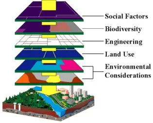
This problem is overcome by combining spatial data and attribute data of the location by appropriate data base management in computers. The location information (spatial data) is digitised from available maps and stored in computers. For this data structure used is either raster data or vector data format.
In raster data structures pick cells are associated with the spatial information, while in vector data structure coordinates are associated with each region and sub-regions. Over the spatial data attribute data is overplayed and stored. Once this geographical information system is developed, the user can access the attribute data of any place by clicking over the spatial data of that place. The user can utilise the information for further analysis, planning or for the management. For example, if land records
of a village is developed as GIS data, the user can click the state map to pick up the district map and then access taluka map. Then he will access it to pick up the village map. Then land record of that village can be obtained and property map of any owner can be checked and printed. All this can be achieved in a very short time from any convenient place. Remote sensing and GIS go hand in hand, since lot of data for GIS is from remote sensing. Remote sensing needs GIS for data analysis. Some of the areas of GIS application are:
1. Drainage systems
2. Streams and river basins management
3. Lakes
4. Canals
5. Roads
6. Railways
7. Land records
8. Layout of residential areas
9. Location of market, industrial, cultural and other utilities
10. Land use of different crops etc.
The above information helps in planning infrastructural development activities such as planning roads, rail routes, dams, canals, tunnels, etc. It helps in taking steps to check hazards of soil erosion and environmental pollution. Monitoring of crop pattern and condition helps in taking necessary action to the challenges in future.