AVIGATION
|
AVIGATION INTRODUCTION |
|
Finding the way from one place to another is called NAVIGATION. Moving of an aircraft from one point to another is the most important part for any kind of mission. Plotting on the paper or on the map a course towards a specific area of the earth , in the passed, used to be a task assigned to a specialised member of the aircraft's crew such a navigator. Such a task was quite complicated and not always accurate. Since it depended on the observation , using simple maps and geometrical instruments for calculations. Today, aerial navigation has become an art which nears to perfection. Both external Navaids (Navigational Aids) and on-board systems help navigate any aircraft over thousand of miles with such accuracy that could only be imagined a few decades ago. |
|
|
|
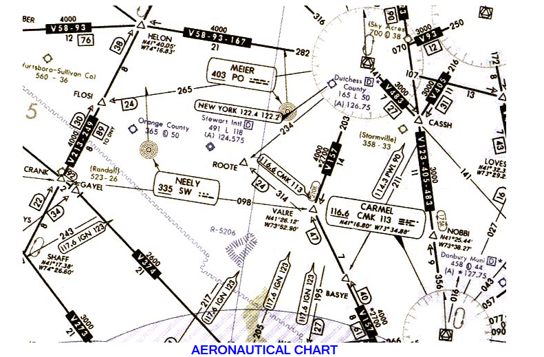
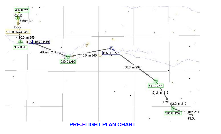
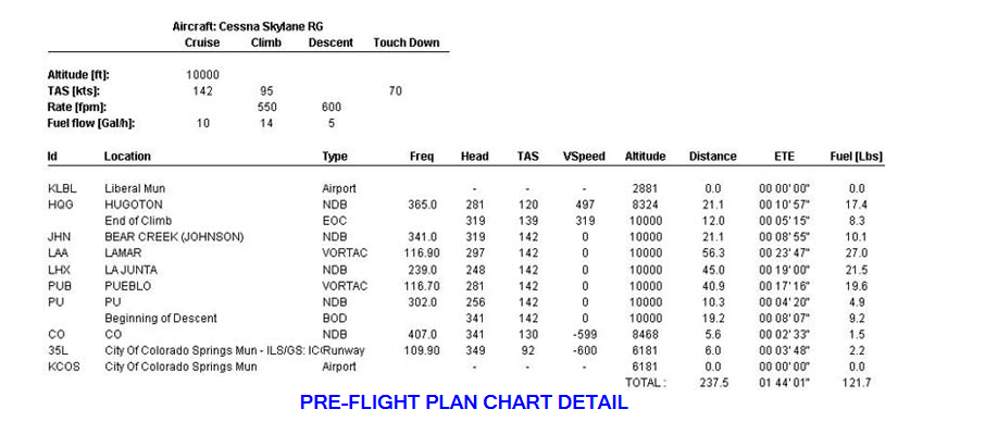
The Method of Navigation Pilotage or Piloting is the most common method of air navigation. This method, the pilot keeps on course by following a series of landmarks on the ground. Usually before take-off, pilot will making pre-flight planning , the pilot will draws a line on the aeronautical map to indicate the desired course. Pilot will nots various landmarks , such as highways , railroad tracks, rivers , bridges . As the pilot flies over each of landmark , pilot will checks it off on the chart or map. If the plane does not pass directly over thelandmark , the pilot will know that he has to correct the course. Dead Reckoning is the primary navigation method used in the early days of flying. It is the method on which Lindberg relied on his first trans-Atlantic flight. A pilot used this method when flying over large bodies of water, forest, deserts. It demands more skill and experience than pilotage does. It is based on time, distance, and direction only. The pilot must know the distance from one point to the next, the magnetic heading to be flown. Pilot works on the pre-flight plan chart , pilot plan a route in advance. Pilot calculate the time to know exactly to reach the distination while flying at constant speed. In the air, the pilot uses compass to keep the plane heading in the right direction. Dead reckoning is not always a successful method of navigation because of changing wind direction. It is the fundamental of VFR flight. Radio Navigation is used by almost all pilots. Pilots can find out from an aeronautical chart what radio station they should tune to in a particular area. They can then tune their radio navigation equipment to a signal from this station. A needle on the navigation equipment tells the pilot where they are flying to or from station, on course or not . |
|
|
|
|
Pilots have various navigation
aids that help them takeoff,fly, and land safely. One of the most important
aids is a series of air route traffic control , operated throughout the world.
Most of the traffic control uses a radar screen to make sure all the planes in
its vicinity are flying in their assigned airways. Airliners carry a special
type of radar receiver and transmitter called a transponder. It receives a
radar signal from control center and immediately bounces it back. When the
signal got to the ground, it makes the plane show up on the radar screen.
Pilots have special methods for navigating across oceans. Three commonly used
methods are:
1. Inertial GuidanceThis system has computer and other special devices that
tell pilots where are the plane located.
2.LORAN Long Range Navigation The plane has equipment for receiving
special radio signals sent out continuous from transmitter stations. The
signals will indicate the plane location
3.GPS Global Positioning System. is the only system today able to show
your exact position on the earth any time, anywhere, and any weather. The
system receiver on the aircraft will receives the signals from sattelites
around the globe.